Exail debuts new transoceanic USV in London
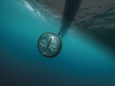
The latest innovation from Exail, a prominent provider of maritime autonomy solutions, is the DriX O-16, a transoceanic uncrewed surface vessel (USV). With an impressive autonomy range of 2,500 nautical...

The latest innovation from Exail, a prominent provider of maritime autonomy solutions, is the DriX O-16, a transoceanic uncrewed surface vessel (USV). With an impressive autonomy range of 2,500 nautical...

Narcisa Pricope is an associate vice president for research in the Office of Research and Economic Development at Mississippi State University and a professor in the Department of Geosciences. Prior...

In the quest to unravel the mysteries beneath our planet’s water bodies, topobathymetric technologies emerge as a beacon of innovation. Among them, Lidar (light detection and ranging) and sonar sensors...
Exail’s DriX uncrewed surface vessel (USV) recently completed a first-of-its-kind fisheries research survey to assess the impact on biomass and fish stock before, during and after wind farm construction. Equipped...

Oceanology International 2024 (Oi24) is set to captivate attendees with a showcase of pioneering companies and innovative technologies, all poised to command attention at London's ExCeL. From advanced autonomous vehicles...

The presence of suspended sediments in water bodies presents significant challenges for the dredging industry. Existing methods to determine nautical depths are intrusive single point methods relying on in situ density or shear strength measurements1,3 or low-frequency single-beam echosounder recordings1,2. The use of single-beam echosounders is however systemically problematic as they are not practical in satisfying the CATZOC A1 coverages required for contemporary electronic navigational charting. The presence of suspended sediments in water bodies presents significant challenges for the dredging industry. Existing methods to determine nautical depths are intrusive single point methods relying on in situ...
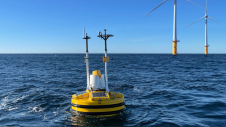
The offshore wind industry knows it can do better. While its potential is undeniable, challenges remain and acknowledging its shortcomings is crucial for progress. Oceanology International 2024 aims to confront...
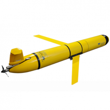
The Slocum glider is buoyancy-driven to enable long-range and duration remote water column observation for academic, military, and commercial applications. It can be deployed and recovered from any size vessel with minimal time on station The Slocum glider is buoyancy driven to enable long range and duration remote water column observation for academic, military, and commercial applications. The Slocum Glider can be deployed and recovered...
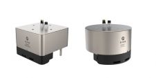
The MS400U is a compact Multibeam Echosounder (MBES) specially designed for USVs or other unmanned platforms. It has a built-in sound velocity sensor and IMU & GNSS, which are the...

IHO standard S-44 is often used (or misused) to specify the quality of a hydrographic survey. While it is a useful tool, it is easy to misinterpret. One ‘misuse’ is...
This site uses cookies. By continuing to use this website, you agree to our Cookies Policy. Agree