Mapping Underwater Habitat
Biosonics’ Visual Habitat DT-X is a software product for the rapid assessment and mapping of aquatic habitat features. With Visual Habitat software, users can present information in a clear and...
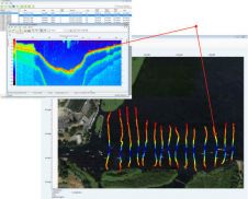
Biosonics’ Visual Habitat DT-X is a software product for the rapid assessment and mapping of aquatic habitat features. With Visual Habitat software, users can present information in a clear and...
The establishment of multi-beam echo sounders (MBES) as a mainstream tool in ocean mapping has revolutionised approaches towards nautical charting, seafloor geotechnical/geological surveys and benthic habitat mapping. The resolution of...
Two decades ago as CO of a survey ship, I interpreted the SSS-registrations (still on wet paper) twice. Once was for nautical charting purposes and the second, in my own...

In an era of great power competition, unmanned maritime systems (UMSs) have begun to take centre stage and are now on an accelerated development path for reasons that are clear....
Teledyne Geospatial has announced that Tetra Tech, a leading provider of high-end consulting and engineering services, recently acquired a Teledyne Optech CZMIL SuperNova Topobathymetric Lidar system. Tetra Tech has successfully...
Kongsberg Discovery, a leading player in oceanographic instrumentation, has introduced a new product innovation to the ADCP market, blending “flexibility, simplicity and high-resolution performance.” Unveiled at Oceanology International, the CP333...
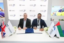
Forum Energy Technologies (FET) has announced that its Subsea Technologies product line executed a memorandum of understanding with an underwater inspections provider, Safeen Survey & Subsea Services, to collaborate on...
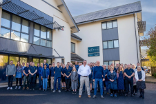
Teledyne Technologies has entered into an agreement to acquire Valeport Holdings Limited and its affiliates (“Valeport”). Established as a dynamic company in 1969 and headquartered in Totnes, United Kingdom, Valeport...
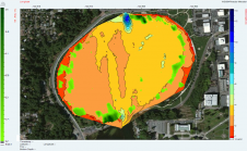
BioSonics, USA, has released Visual Habitat 2.0 (VH2), specialised software for the assessment and mapping of aquatic habitat features including seagrass, bathymetry, and various substrate types. This upgraded version includes...

In the quest to unravel the mysteries beneath our planet’s water bodies, topobathymetric technologies emerge as a beacon of innovation. Among them, Lidar (light detection and ranging) and sonar sensors...
This site uses cookies. By continuing to use this website, you agree to our Cookies Policy. Agree