Offshore Windfarm Survey on Gunfleet Sands
In recent years an expansion in the telecommunications cable industry led to an increase in the market for cable route landfall surveys incorporating geophysical surveys at sea and topographic surveys...
In recent years an expansion in the telecommunications cable industry led to an increase in the market for cable route landfall surveys incorporating geophysical surveys at sea and topographic surveys...
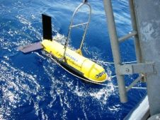
The Student Autonomous Underwater Challenge – Europe (SAUC-E) is an annual event providing an opportunity for student-led teams to design and build a small autonomous underwater vehicle (AUV) to compete...
Ports and harbours vary in size, use and importance; for example, from relatively small local fishing ports to the really large international ports of major importance to international commerce and...
An EdgeTech 2400-DSS deep-towed side-scan sonar system, owned and operated by Odyssey Marine Exploration, was used to find a shipwreck code-named the "Black Swan" which yielded over 500,000 silver and...
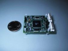
AOSI's EZ-COMPASS-3AL LOGGING Compass incorporates a three-axis Magnetometer with tilt and temperature compensation and a onboard rewritable memory that allows independent storage of up to 20,000 readings and transferable to...

HYPACK, A Xylem Brand has been developing HYPACK®, HYSWEEP®, and DREDGEPACK® software solutions since 1984. With over 30 years’ experience, and over 10,000 users, HYPACK is a leading provider of...
It is an honour to have this opportunity to write this column for Hydro International as the director of one of the world’s oldest hydrographic national offices. Please remember that...
The U.S.S Niagara, a steam-run and sail-powered frigate launched in 1856 and commissioned in 1857, was a part of the Civil War northern blockading fleet and escort, which also played...
The Australian Navy is the latest military unit to purchase JW Fishers Proton 4 magnetometers. The Aussies join a long list of military clients using Fishers underwater search equipment including...
Present-day hydrographic surveys can result in many types of information that are used for planning inland dredging projects. Novel geophysical survey systems provide detailed information on sediment composition and pollution...
This site uses cookies. By continuing to use this website, you agree to our Cookies Policy. Agree