Fast-tracking the evolution of unmanned maritime systems
In an era of great power competition, unmanned maritime systems (UMSs) have begun to take centre stage and are now on an accelerated development path for reasons that are clear....

In an era of great power competition, unmanned maritime systems (UMSs) have begun to take centre stage and are now on an accelerated development path for reasons that are clear....

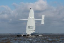
The latest innovation from Exail, a prominent provider of maritime autonomy solutions, is the DriX O-16, a transoceanic uncrewed surface vessel (USV). With an impressive autonomy range of 2,500 nautical...

In the quest to unravel the mysteries beneath our planet’s water bodies, topobathymetric technologies emerge as a beacon of innovation. Among them, Lidar (light detection and ranging) and sonar sensors...
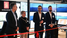
Autonomous vessel operations company Massterly has opened its Remote Operations Centre (ROC) in Horten, Norway. This significant step marks a crucial transition from the testing phase to fully-fledged operational capabilities...
Saildrone announced the launch of its first aluminium Surveyor unmanned surface vehicle (USV) from the Austal USA production line in Mobile, Alabama. Chief of Naval Operations (CNO) Adm. Lisa Franchetti was...
Exail’s DriX uncrewed surface vessel (USV) recently completed a first-of-its-kind fisheries research survey to assess the impact on biomass and fish stock before, during and after wind farm construction. Equipped...

Oceanology International 2024 (Oi24) is set to captivate attendees with a showcase of pioneering companies and innovative technologies, all poised to command attention at London's ExCeL. From advanced autonomous vehicles...
A 120-year-old mystery has been solved with the help of a CSIRO team aboard the RV Investigator. Heritage NSW has announced the discovery of the SS Nemesis, a 73-metre iron-hulled...

IIT Madras has established a Centre of Excellence (CoE) dedicated to advancing indigenous maritime technology and expertise. The team of researchers leading this initiative has been actively engaged in notable...

The Danish Geodata Agency, alongside several collaborators, is currently conducting trials on the latest iteration of navigational charts in the Baltic Sea region. This initiative forms part of an EU-funded...
This site uses cookies. By continuing to use this website, you agree to our Cookies Policy. Agree