Record low: Antarctic sea ice melts to unprecedented levels
The amount of sea ice in the Antarctic has reached a record low, with levels not seen in the past 40 years of satellite observation. On 8 February 2023, only...
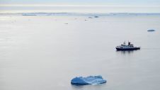
The amount of sea ice in the Antarctic has reached a record low, with levels not seen in the past 40 years of satellite observation. On 8 February 2023, only...
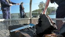
Marine archaeologists from Vrak – Museum of Wrecks in Stockholm, Sweden, have uncovered the wreck of the 17th-century warship Äpplet. Launched in 1629, the ship was built by the same...
Kongsberg emphasizes its ambition to shape the future of the maritime industry by creating new opportunities in the ocean space. To further this mission, Kongsberg has established Sensors & Robotics...

Climate change is having a significant impact on the hydrographic industry, and many organizations are taking steps to reduce emissions and minimize their environmental footprints. Such steps include using more...
Taking into account the increasing demand for autonomy in hydrography, this article examines the development of an innovative, small-sized subsea sensor fusion solution. This groundbreaking solution has the potential to...

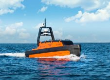
SEA-KIT International has announced its first uncrewed surface vessel (USV) export sale to ThayerMahan, a leading provider of autonomous maritime solutions based in Connecticut, USA. The X-Class USV’s combination of...
Every year, Hydro International surveys the state of the hydrographic industry to gain a comprehensive understanding of the sector and the challenges it faces. The survey includes a series of...
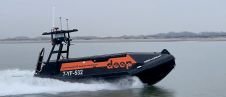
HydroSurv, a UK-based company in the uncrewed surface vessel (USV) sector, recently announced a partnership with Danish engineering company EIVA to supply autopilots for a lease fleet of USVs. The...
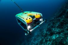
A Saab Seaeye Falcon underwater robot has helped complete the first-ever systematic scientific survey of the waters of the Maldives — the lowest-lying nation on earth. The Maldives is just...
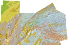
The British Geological Survey (BGS) has released a new fine-scale digital map featuring the seabed geology of offshore Anglesey. The island (in Welsh known as Ynys Môn) follows the Bristol Channel as...
This site uses cookies. By continuing to use this website, you agree to our Cookies Policy. Agree