The evolution of Dutch hydrography
Given the Netherlands’ geographical location, it is unsurprising to find it has a long tradition of hydrography. The lowland, often below sea level, forms a delta where major rivers from...

Given the Netherlands’ geographical location, it is unsurprising to find it has a long tradition of hydrography. The lowland, often below sea level, forms a delta where major rivers from...

Fujitsu has presented a pioneering technology that harnesses Lidar and AI to capture high-resolution 3D data of organisms, coral reefs and man-made structures such as offshore wind turbines using autonomous...

A consortium of USV and hydroacoustic tech firms, including ACUA Ocean, GeoAcoustics and Unmanned Survey Solutions (USS), has secured funding from the British Department for Environment, Food and Rural Affairs...

By harnessing capabilities of advanced satellite technology and ever-evolving data analysis, satellite-based mapping (including satellite-derived bathymetry, SDB) offers an efficient, extensible and cost-effective method for mapping water properties, underwater topography...

The presence of suspended sediments in water bodies presents significant challenges for the dredging industry. Existing methods to determine nautical depths are intrusive single point methods relying on in situ density or shear strength measurements1,3 or low-frequency single-beam echosounder recordings1,2. The use of single-beam echosounders is however systemically problematic as they are not practical in satisfying the CATZOC A1 coverages required for contemporary electronic navigational charting. The presence of suspended sediments in water bodies presents significant challenges for the dredging industry. Existing methods to determine nautical depths are intrusive single point methods relying on in situ...

Ocean surveying and inspection specialist Argeo Subsea, CSI Nordics and Kongsberg Discovery have formalized a three-party Certificate of Delivery and Acceptance for an advanced HUGIN Superior AUV. This milestone agreement,...

Between January 2023 and February 2024, TDI-Brooks, a specialized company in geotechnical and offshore survey projects, conducted an extensive site investigation programme across two offshore wind blocks in state and...
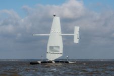
Saildrone announced the launch of its first aluminium Surveyor unmanned surface vehicle (USV) from the Austal USA production line in Mobile, Alabama. Chief of Naval Operations (CNO) Adm. Lisa Franchetti was...
Lidar, short for Light Detection and Ranging surveying, represents a sophisticated measuring system leveraging the power of light. Widely recognized for its versatility, Lidar is extensively applied in diverse fields...

Kongsberg Discovery commemorates 30 years of inertial navigation excellence with the launch of Seapath 385. Unveiled at Oceanology International in London, this innovative system integrates new hardware and advanced navigation...
This site uses cookies. By continuing to use this website, you agree to our Cookies Policy. Agree