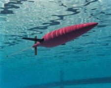
Found 1330 results
Sort by

Improved Chart Production and Data Management

Esri, USA, has released a solution to support users in port management, maritime transport, coastal management, offshore energy, nautical chart production, and maritime defence. ArcGIS for Maritime: Charting and ArcGIS...

Read more

NOAA's NCS II Centralises Chart Production

The National Oceanic and Atmospheric Administration (NOAA, USA) has implemented a new nautical charting system based on Esri GIS technology to produce more navigational products than ever before without increasing...

Read more

Boost for NOAA Nautical Chart Production

NOAA's development of a new navigational chart processing system moved to initial limited production on 21st September 2011. The new system, which slims down the current map production process while...

Read more

USD30M Localiation System Production Option

Bluefin Robotics, USA, is being awarded a USD30 million contract modification to exercise option III for the Explosive Ordnance Disposal Hull Unmanned Underwater Vehicle Localization Systems (HULS) production systems. The...

Read more

Weather Buoys Roll Off Production Line

Axys Technologies sees a demand for its buoys, resulting in deliveries all over the world. The Marine Institute at Memorial University in Newfoundland has recently deployed two new monitoring platforms...

Read more