Tips & Tricks
The place: Cross River, Nigeria, the year: 1974.... Well before RTK, GPS, computers, GIS, total stations, laptops and all those other toys that make a surveyor’s life bearable nowadays. We...
The place: Cross River, Nigeria, the year: 1974.... Well before RTK, GPS, computers, GIS, total stations, laptops and all those other toys that make a surveyor’s life bearable nowadays. We...
Hydrographic Charts for seafarers are based on years of survey data. Standard charts, paper or ENC, are available for most areas of the world and are quite inexpensive thanks to...
In conjunction with Ocean Business 2007, the conference Offshore Survey 2007 is organised. Adam Kerr followed the lectures and reports about them. After the coffee break, the programme turned to...
The intertidal zone, where coastal wetlands provide the first buffer to storm energy and sea level rise, has not traditionally been a focus of geodetic surveying. However, the increasing vulnerability...
Trimble has been selected by the Greek National Cadastre, Ktimatologio, to supply Trimble VRS network hardware and software to establish a nationwide Global Navigation Satellite System (GNSS) infrastructure network for...
Magellan has announced its exclusive BLADE (Base Line Accurate Determination Engine) technology, a GNSS processing solution that facilitates centimeter-level accuracy for real-time and post-processing surveys and mapping operations. Magellan’s BLADE...
The DG14 RTK offers high-precision in a low-cost GNSS unit. The DG14 RTK from Magellan is a sub-meter GNSS (GPS + SBAS) and Beacon receiver. DG14 RTK was developed to...

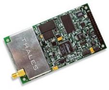
ArWest Communications Corporation has been awarded a contract by Topcon Positions Systems to provide 1 Watt UHF transceivers integrated within the Topcon GR-3 triple constellation RTK Satellite Receiver. The...
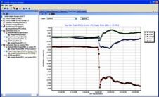
Trimble has introduced an application for monitoring the dynamics of Global Navigation Satellite System (GNSS) infrastructure networks: Trimble Integrity Manager software. In a GNSS network, movement of a reference antenna...
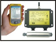
TideM8 is a combination of the Ohmex TideM8 miniature tide gauge system and Trimble's Juno hand-held Mobile PC with integrated GPS. The system is a new design based on the...
This site uses cookies. By continuing to use this website, you agree to our Cookies Policy. Agree