Green Masterplan for Tianjin Expansion of Into the Sea
Tianjin is China’s main import harbour. The population of the area surrounding the port, the Tianjin Economic Development Area (TEDA), is expected to increase by more than 200,000 over the...

Tianjin is China’s main import harbour. The population of the area surrounding the port, the Tianjin Economic Development Area (TEDA), is expected to increase by more than 200,000 over the...
Navionics has added a new coverage size for its Gold+ Charts, XL9 for the Americas, Europe and Rest of the World. Providing over three times the coverage previously available in...
The General Acoustics (Germany) has appointed “S.E.A. Corporation” from Ichikawa City as their new exclusive agent for Japan. Also in Poland a new partner could be found. It is Eko...
AHS Education Award 2006 The AHS president and Education Award Board are delighted to advise that there were sixteen applicants for the 2006 award. These included research proposals from New...
This paper describes the development of a web spatial image server used for sharing huge sets of georeferenced coastal orthophotos on the web via an easy visualisation interface. Traditional cartography...
Imagine piloting a 398m container ship into port TODAY using an ENC updated with survey data collected YESTERDAY. Isn’t this order of turnaround time the ultimate dream of any ENC...
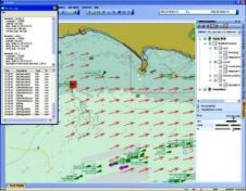
Specially adapted Kongsberg Norcontrol IT C-Scope software formed the platform for an in- depth MarNIS (Maritime Navigation and Information Services) demonstration, held at the MCA's Highcliffe Training Centre on 13...
In conjunction with Ocean Business 2007, the conference Offshore Survey 2007 is organised. Adam Kerr followed the lectures and reports about them. After the coffee break, the programme turned to...
Following meetings in St. Petersburg in 1908 and 1912, twenty-four nations gathered in London in 1919 for a Hydrographic Conference during which they decided to create an International Hydrographic Bureau...
Following international agreements, the Hydrographic Service of the Royal Netherlands Navy is in the process of changing the Chart Datum in its nautical charts and other products from Mean Lower...
This site uses cookies. By continuing to use this website, you agree to our Cookies Policy. Agree