Lines in the Sea
Under the 1982 United Nations Convention on the Law of the Sea (UNCLOS) coastal states may claim rights over the resources of the sea and seabed up to 200 nautical...
Under the 1982 United Nations Convention on the Law of the Sea (UNCLOS) coastal states may claim rights over the resources of the sea and seabed up to 200 nautical...
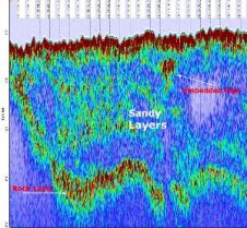
The “SUBPRO 1210” Sub-Bottom Profiler will be featured at the US Hydro Conference from 14th to 17th May at booth 35, which is shared with General Acoustics’ US representative Seafloor...
US Hydro 2007 Conference takes place this month in Norfolk, Virginia, organised by the Hydrographic Society of America. It will be the eleventh event of its kind, celebrating the two...
The intertidal zone, where coastal wetlands provide the first buffer to storm energy and sea level rise, has not traditionally been a focus of geodetic surveying. However, the increasing vulnerability...

U.S. Mariners use the resources of NOAA's Navigation Services to safely navigate U.S. coastal waters. In recognition of this landmark 200th anniversary of the establishment of the Survey of the...
Google Earth and its related layer language Keyhole Markup Language (KML) have taken the mapping world by storm. Combining an approachable user interface, high-quality satellite imagery, and free cost (for...
Global warming, climate change, rising sea levels and increased commercial exploitation of the seabed and sea space are important global indicators of a changing world environment. A crucial role is...
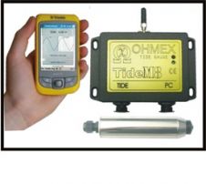
TideM8 is a combination of the Ohmex TideM8 miniature tide gauge system and Trimble's Juno hand-held Mobile PC with integrated GPS. The system is a new design based on the...

RBR Ltd adds RBR Europe Ltd in the UK. This new Sales Office will complement the engineering and sales support that has been provided from RBR Europe GmbH in Germany...
Narrow tidal channels often provide challenges to shipping. Reliable charting of tidal-stream flow is important for safety. Acoustic Doppler current-profiler (ADCP) survey is now a commonplace method of charting tidal...
This site uses cookies. By continuing to use this website, you agree to our Cookies Policy. Agree