Found 137 results
Sort by

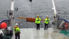
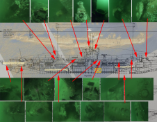
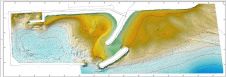
Innomar Technologie GmbH

INNOMAR provides parametric sub-bottom profilers and associated software, which are perfectly suited for high-resolution sub-seabed visualisation in water depths from less than one meter to full ocean depth. Applications include,...

Read more

Dangerous war remnants

Countless ships and aircraft were lost at sea in the two world wars. Many of these went down with a large amount of fuel and munitions onboard, not to forget...

Read more

Challenging Marine Geophysical Survey in Looe Bay

LandScope Engineering’s multipurpose survey vessel Investigator has recently completed a marine geophysical survey in Looe Bay, Cornwall, UK, in support of breakwater and pier development works. High-resolution UAV photogrammetric data...

Read more

Better Safe Than Sorry

There is nothing worse in any project than finding wrecks or unexploded ordnance (UXO) after construction has started, writes Huibert-Jan Lekkerkerk in his article ‘Sub-bottom Object Detection’. When a new...

Read more

Hydro International #4 - 2021

Clouds trace out the islands of the Caribbean Sea in this photo taken by an astronaut from the International Space Station. Beyond the solar arrays and the docked Progress resupply vehicle, the multitoned waters of the Caribbean and the Atlantic Ocean frame the Bahamas, Cuba, Jamaica and southern Florida. Clouds trace out the islands of the Caribbean Sea in this photo taken by an astronaut from the International Space Station. Beyond the solar arrays and the docked Progress resupply...

Read more