Found 256 results
Sort by

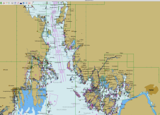
Norwegian ENC Data in OpenCPN

Updated Norwegian electronic navigational chart (ENC) data can now be downloaded and used in the open-source chart plotter and navigation software, OpenCPN. The Norwegian Mapping Authority Hydrographic Service's electronic navigational...

Read more

Changes to data sourcing in modern times

Seaports, waterways and climate are inextricably linked. Weather anomalies change bottom contours and destroy aids to navigation, compromising safety. In the past decade, maritime applications, maturing marine technologies and crowdsourcing...

Read more