Low-budget Hydrography: the hows and whys
Hydrographic Charts as used by seafarers are based on data accumulated over years of professional surveying operations. Standard hydrographic charts either in paper form or as ENC are available for...
Hydrographic Charts as used by seafarers are based on data accumulated over years of professional surveying operations. Standard hydrographic charts either in paper form or as ENC are available for...
Monfils, R., Gilbert, T. and Nawadra S., 2006.Ocean & Coastal Management Selected Papers from the East Asian Seas Congress 2003, Putrajaya, Malaysia, 49: pp 779-788.Oil, chemicals and unexploded ordinances onboard...
The 4th international conference on high-resolution surveys in shallow waters took place in Plymouth (UK) from 12 to 15 September. The conference focused on the ‘Common Data Set’ (comparison data...
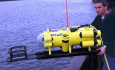
US Government agencies, including the US State Department, a US Navy maintenance facility, and an Emergency Management Agency in Wyoming, are purchasing JW Fishers SeaLion ROVs. An official at the...
Over the past thirteen years Douglas-Westwood Limited has produced a series of occasional techno-economic studies of the Ocean Survey industry. This latest, The World Ocean Survey Report 2004-2008 aims to...
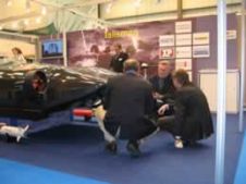
BAE Systems launched its new autonomous unmanned underwater vehicle (UUV) Talisman at Oceanology International 2006. The Talisman System, developed by BAE Systems in the UK, is a latest-generation modular multi-role...
Surveying in the near-shore or surf zone is, without doubt, a technical and operational challenge. And this remains true despite the fact that GNSS-positioning and the drastic reduction in size...
My first experience in the navy with data collecting for oceanography was taking part in a MILOC-survey (military oceanography), near the Azores in the 1960s. It took us 24 hours...
The Hydrographic Department Royal Thai Navy (HDRTN), founded in 1919, is the Thai government organisation under the control of Royal Thai Navy responsible for surveying Thai navigable waterways and producing...
The 8th annual International Lidar Mapping Forum (ILMF) held in Denver (CO, USA) from 21 to 22 February 2008 turned out to be the best ever. With over 580 registered...
This site uses cookies. By continuing to use this website, you agree to our Cookies Policy. Agree