GIS in Mapping Ocean Floor
Ocean Globe from ESRI Press examines bathymetry from its early history through today's use of geographic information systems (GIS) and other technologies to map the ocean floor. With contributions from...
Ocean Globe from ESRI Press examines bathymetry from its early history through today's use of geographic information systems (GIS) and other technologies to map the ocean floor. With contributions from...

In these austere times, there is increasing pressure on publicly-funded bodies to co-operate, collaborate and pool their resources. The field of hydrographic surveying is certainly not exempt from these difficult...
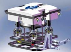
Sperre, Norway, is developing a new ROV concept (H-ROV) that is expected to make remotely controlled underwater operations more efficient. The concept distinguishes from ordinary ROVs is that its thrusters...
ODIM Brooke Ocean has received an order for the delivery of an ODIM LOPC to the Department of Biology, Institute for Coastal Science and Policy East Carolina University. The LOPC...

Scientists embark this week from Alaska on the second and final leg of a NASA field campaign to study how changing conditions in the Arctic affect the ocean's chemistry and...
C&C Technologies has opened its Stonewall, Louisiana office, as well as its appointment of Josh McDaniel as senior regulatory specialist. McDaniel's background includes a degree in wildlife biology from Louisiana...
In June 2011, the UK's National Oceanography Centre (NOC) is to take part in an ambitious project to ‘spread the word' about marine research and the importance and vulnerability of...
Scientists from the Institute for Ocean Conservation Science at Stony Brook University (SBU), who also are members of the university's faculty, are teaching the first course offered through the new...
The Gulf of Mexico Research Initiative (GRI) Research Board announced that up to USD1.5 million in grants will be available to provide funds for the acquisition of samples and critical...

A British scientific expedition has discovered the world's deepest undersea volcanic vents, known as 'black smokers', 3.1 miles (5,000 metres) down in the Cayman Trough in the Caribbean. Using a...
This site uses cookies. By continuing to use this website, you agree to our Cookies Policy. Agree