New SEA Swathplus Range
The Marine Division of the British-based SEA Group has a new range of wide-swath, shallow-water sonar: the SWATHplus. SEA acquired the rights to what was the Submetrix system in May...
The Marine Division of the British-based SEA Group has a new range of wide-swath, shallow-water sonar: the SWATHplus. SEA acquired the rights to what was the Submetrix system in May...
Only from 2006, TerraSAR-X will be delivering Earth observation data of a new quality, however, its´ commercial exploitation starts now: two years prior to the scheduled launch date. The Friedrichshafen-based...
Merrick & Company has released its free MARS Viewer at the International LIDAR Mapping Forum (ILMF) 2006. MARS Viewer is an intuitive, easy-to-use viewing application for LIDAR and associated terrain...
The Italian Istituto Nazionale di Fisica Nucleare (INFN) is developing a large underwater apparatus to investigate new frontiers in astrophysical research. The NEutrino Mediterranean Observatory, NEMO, consists of a 3D-array...
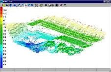
HYPACK has released HYPACK 6.2B, which version includes updates to HYPACK 6.2A and new features. Among some of the features of Version 6.2B are new Point Cloud editing tool ,...
HYPACK, A Xylem Brand has been developing HYPACK®, HYSWEEP®, and DREDGEPACK® software solutions since 1984. With over 30 years’ experience, and over 10,000 users, HYPACK is a leading provider of...
The HYPACK 2008 Training Conference will be held at the Westin Savannah Harbor Golf Resort & Spa. The 3-day training from 6 to 9 January 2008 will cover all the...
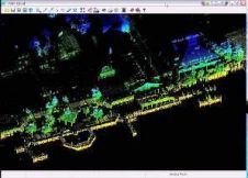
HYPACK version 2008 will be introduced at the HYPACK 2008 training conference from 6 to 9 January 2008. It has a new look with floating tool bars, multiple views for...
The French Hydrographic Office (SHOM) uses remotely sensed visible imagery for the cartography of atolls and reefs. It is considered as an efficient and relatively inexpensive method to collect information...
The Hydrographic Survey (Søopmålingen) which is a part of the Oceanographic division within the Royal Danish Administration of Navigation and Hydrography (RADON), conducts hydrographic surveying in the Danish and Greenland...
This site uses cookies. By continuing to use this website, you agree to our Cookies Policy. Agree