Oceanology International to have Three Points of Focus
When Oi08 opens at the ExCeL centre in London’s Docklands on 11 March, the exhibition and its accompanying conference will focus on the three important issues that have begun to...
When Oi08 opens at the ExCeL centre in London’s Docklands on 11 March, the exhibition and its accompanying conference will focus on the three important issues that have begun to...
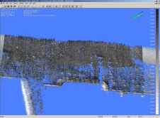
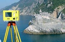
Laser scanning and bathymetric side-scan sonar represent the cutting edge of environmental survey technology. Over the last few years, we have tested the integration of these two methodologies, carrying out...
Remote sensing of oil spills in conjunction with their prevention and combat has long since evolved into a key element for the protection of the marine environment. The impact of...
In the 18th century, a trading ship was on a passage in the Bay of Bengal. There were 250 people on board the sailing ship. The sea through which they...
The geospatial technologist of Google, Ed Parsons, will give a Lecture on 5th of March at 12 PM in Barcelona's Congress Centre on occasion of Globalgeo 2009. During his address,...

Among the most exciting advances in remote sensing are the innovations being made in multi-sensor data fusion. This can exponentially increase both the quality and quantity of information in the...
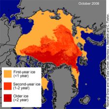
New evidence from satellite observations shows a continuation in the decade-long trend of shrinking Arctic sea-ice cover and a thinning ice cap. The latest data comes from NASA and the...
When surveying the coastline, the integration of bathymetric (below sea level) and laser scanning (above sea level) data causes problems due to the different imaging properties. However, by ensuring that...

Once upon a time, the study of the Earth’s surface, its features, inhabitants and phenomena was nothing more than a tiresome school subject for the average person on the street....
IVS 3D announced its partnership with Geomatics Data Solutions to provide sales, support, and training to Fledermaus clients located on the western coast of North America. With over 25 years...
This site uses cookies. By continuing to use this website, you agree to our Cookies Policy. Agree