Dreaming away...
A sunny day with some dark clouds in the sky – a typical day in June at the Dutch estuary. I have just finished my exams and am sitting on...
A sunny day with some dark clouds in the sky – a typical day in June at the Dutch estuary. I have just finished my exams and am sitting on...
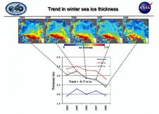
Arctic sea ice thinned between the winters of 2004 and 2008, with thin seasonal ice replacing thick older ice as the dominant type for the first time on record. The...

Dr Salem E. Masry, president and chief executive officer of CARIS, accepted to be interviewed by Hydro international on the occasion of the 30th anniversary of his enterprise. Dr Masry,...
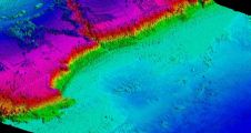
A new bathymetric survey of the Corsican coastline has been commissioned to provide detailed information about ongoing coastal erosion on the Mediterranean island as well as to assess the impact...
NASA begins a series of flights 15th October to study changes to Antarctica's sea ice, glaciers and ice sheets. The flights are part of Operation Ice Bridge, a six-year campaign...
This is the continuation of the Oceanology International Preview. For companies A - L, see part 1 MacArtney Underwater Technology Group MacArtney will be introducing their newest innovation in multiplexers...
Applanix introduced today the latest LANDMark Marine mobile mapping solution, which enables the creation of seamless models of near shore environments by providing a georeferenced point cloud which integrates with...
NASA's Operation IceBridge mission, the largest airborne survey ever flown of Earth's polar ice, kicks off its second year of study when NASA aircraft arrive in Greenland 22nd March. The...
The AntiNoise plugin module for NaviModel Digital Terrain Modeling software is developed in close cooperation with SCALGO, a Danish company founded in 2009 and specialised in software for massive terrain...
Amongst the largest contracted coastal hydrographic Lidar survey projects awarded in recent years is the Australian Hydrographic Service (AHS) survey of the Torres Strait in Northern Queensland. The intent of...
This site uses cookies. By continuing to use this website, you agree to our Cookies Policy. Agree