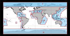
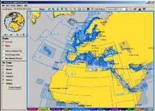
Found 539 results
Sort by

Geospatial Data Updating at Sea

A growing problem exists with forward-deployed electronic chart display and information systems (ECDIS) in obtaining and updating geospatial data(electronic nautical charts). This problem is commonly referred to as distributing geospatial...

Read more

Hydrographic Information Databases

The availability of various sensors and sophisticated technology providing digital data means that today’s hydrographers must attune to the idea that the final products should be available in a hydrographic...

Read more

MESH Maps Come Online

An international team of scientists, working over the last four years, has developed a framework for Mapping European Seabed Habitats (MESH). The project achievements far exceeded those originally planned, and...

Read more

Google Earth Meets the Sea

Google Earth and its related layer language Keyhole Markup Language (KML) have taken the mapping world by storm. Combining an approachable user interface, high-quality satellite imagery, and free cost (for...

Read more

Mean Rise in Sea Level

The Tunisian Naval Hydrographic and Oceanographic Center (TNHOC) has since 1999 maintained a tidal database through an in situ tide-gauge network along the Tunisian coast. The data collected so collected...

Read more

Surveying the Gulf of Mexico

Surveying and mapping for the offshore petroleum industry in the Gulf of Mexico (GOM) has been a source of confusion and wonder, especially to non-US nationals working there for the...

Read more

International Bathymetric Charts

Since the 1970s, the International Bathymetric Charts (IBCs) of the Intergovernmental Oceanographic Commission have offered a framework for compiling soundings with a view to producing detailed maps of sea floor...

Read more

ENCs

At its 81st session, the Maritime Safety Committee decided to develop a strategic vision for e-navigation to integrate existing and new navigation tools in an all-embracing system that will contribute...

Read more