New Depth Map over the Arctic Ocean
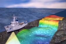
Details of a new depth map of the Arctic Ocean have been published in the Nature Journal Scientific Data. The new portrayal of the Arctic Ocean floor is in the...
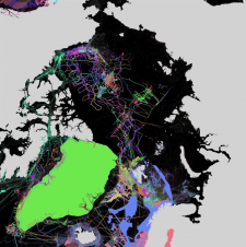
Details of a new depth map of the Arctic Ocean have been published in the Nature Journal Scientific Data. The new portrayal of the Arctic Ocean floor is in the...
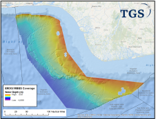
TDI-Brooks International (under contract to TGS) has completed the offshore multibeam phase offshore the Niger Delta. This survey took place in water depths of 750 to 3,500 metres and is...
Recently, the European Marine Board published a report on the current status of the European fleet of research vessels. This Position Paper describes how the fleet will need to develop in the future to ensure that it will continue to provide the same high level of support to science and hydrography globally, as well as highlighting ways in which management could be made more efficient. This article is an extract of the report. Recently, the European Marine Board published a report on the current status of the European fleet of research vessels. This position paper describes how the fleet will need to develop...

Denmark has challenging seascapes to map and chart. It has a rich history of nautical charting that dates back to the seventeenth century, and many of its navigational products for...

Jamie McMichael-Phillips, the new director of The Nippon Foundation-GEBCO Seabed 2030 Project, has now taken up his position in leading one of the most challenging projects of the next decade,...
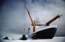
When I started writing this blog, I remembered a news item on an exciting expedition due to set off to the Arctic waters that was published on our website. It said: „On the evening of 10 August 2019, the research vessel Polarstern left her homeport in Bremerhaven, Germany. The purpose of the expedition is to conduct studies at a major long-term monitoring station in the Arctic: the AWI’s Hausgarten observatory in the Fram Strait.” When I started writing this blog, I remembered a news item on an exciting expedition due to set off to the Arctic waters that was published on our website. It...
When I started writing this blog, I remembered a news item on an exciting expedition due to set off to the Arctic waters that was published on our website. It...
Three new global initiatives for mapping the world’s entire ocean floor have been announced in London at a special conference organised by The Nippon Foundation-GEBCO Seabed 2030 Project, the international...

EOMAP has been awarded by the German Aerospace Center (DLR) to further develop its physics-based method of mapping the depth of the sea from satellite observations. Satellite-Derived Bathymetry (SDB) uses data...
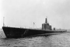
Tim Taylor and his team of the Lost 52 Project have identified the bow of the USS Grunion. It was discovered about a quarter of a mile from the main wreckage....
This site uses cookies. By continuing to use this website, you agree to our Cookies Policy. Agree