Italo Oliveira Ferreira
Italo Oliveira Ferreira is a professor in Geomatic Engineering at the Federal University of Viçosa (UFV). He is a geomatic engineer with a Master’s and Doctorate in Spatial Information (Geodesy...

Italo Oliveira Ferreira is a professor in Geomatic Engineering at the Federal University of Viçosa (UFV). He is a geomatic engineer with a Master’s and Doctorate in Spatial Information (Geodesy...
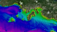
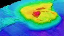
Since the 1970s, remote sensing has increasingly been used to conduct underwater surveys. Several methodologies are employed in hydrographic surveying, from direct techniques such as probing rods to more sophisticated...
We asked five experts for their views on the trends and developments in bathymetric data, as this is and will continue to be the backbone of hydrographic surveying with echosounders,...
SeaTrac Systems has announced the sale and delivery of one of its SP-48 persistent uncrewed surface vehicles (USVs) to an elite geosciences team at Princeton University. Working with long-time collaborator...
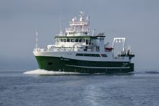
Ireland’s multipurpose marine research vessel RV Tom Crean has entered service equipped with Ultra-Short BaseLine (USBL) underwater positioning technology from ocean science company Sonardyne. Delivered in July, the 52.8m-long vessel...
Witold Kazimierski, navigator and GIS specialist, received a PhD in geodesy and cartography in 2008. He is currently an associate professor at the Maritime University of Szczecin, Poland, and focuses...
Jacek Łubczonek conducts research on hydrographic and topographic data processing using geoinformatics techniques and artificial intelligence methods at the Maritime University of Szczecin, Poland. He received a PhD in geodesy...
In this interview, Harald Sternberg, Professor of Hydrography and Geodesy at HafenCity University, shares his thoughts on the key market trends, technology drivers and challenges, and the impacts of COVID-19...
Herjuno Gularso is a mapping surveyor at the Center for Marine and Coastal Environment Mapping at the Geospatial Information Agency. He received a Bachelor’s degree in Geodesy Engineering from Diponegoro...
Agung Syetiawan is a researcher in the Geospatial Information Agency of Indonesia. He received his Master’s degree in Geodesy and Geomatics Engineering from Bandung Institute of Technology, Indonesia. His research...
This site uses cookies. By continuing to use this website, you agree to our Cookies Policy. Agree