FIG Advisory Committee of Commission Chairs (ACCO)
It has been said that the commissions serve as the engine for FIG. The chairs of each commission interact collectively with FIG Council and our membership at large via the...
It has been said that the commissions serve as the engine for FIG. The chairs of each commission interact collectively with FIG Council and our membership at large via the...
There is a global shortage of hydrographic surveyors. Vacancies and demands for personnel at sea mean surveyors are becoming the most wanted specialists in the offshore world. Institutes of hydrographic...
NovAtel Inc. has been selected by Deloitte as a Fast 50 Leadership award winner. The Fast 50 Leadership awards recognize superior business performance judged against the norms of individual technology...
The Association of Canada Lands Surveyors (ACLS) is a national multidisciplinary organisation representing geomatics professionals engaged in hydrography, geodesy, remote sensing, GIS, data management and cadastral surveying. In co-operation with...
With extended national jurisdiction offshore brought about by the coming into force of the United Nations Convention on Law of the Sea (UNCLOS), new territories have emerged that need to...
In the last half century Hydrography has grown from a Government commitment, solely for the purpose of producing nautical charts and information for safe navigation, into a science indispensable to...
It may look as though Europe, the USA and Canada, followed by Australasia, dominate the hydrographic world scene. But there must also be enormous potential in the area north of...
There is much current activity on the hydrographic scene in the Far East region; the area was hit by the Tsunami, 26th December 2004. The region is also on the...
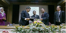
A B$9.5 million project for the delivery of Brunei's national Spatial Data Infrastructure (NSDI) was officially contracted end of April 2007 during a signing ceremony between the Ministry of Development...
Development of a vertical surface separation model will allow easier assimilation of land and maritime data sources, resulting in seamless vertical data. The future possibilities of having data that can...
This site uses cookies. By continuing to use this website, you agree to our Cookies Policy. Agree