The evolution of Dutch hydrography
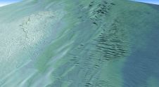
Given the Netherlands’ geographical location, it is unsurprising to find it has a long tradition of hydrography. The lowland, often below sea level, forms a delta where major rivers from...

Given the Netherlands’ geographical location, it is unsurprising to find it has a long tradition of hydrography. The lowland, often below sea level, forms a delta where major rivers from...
Teledyne Geospatial has announced that Tetra Tech, a leading provider of high-end consulting and engineering services, recently acquired a Teledyne Optech CZMIL SuperNova Topobathymetric Lidar system. Tetra Tech has successfully...
Lidar, short for Light Detection and Ranging surveying, represents a sophisticated measuring system leveraging the power of light. Widely recognized for its versatility, Lidar is extensively applied in diverse fields...

How do you perceive prospects in the hydrographic surveying industry in 2024, compared to the past couple of years? When contemplating the hydrographic sector holistically, which areas of investment do...
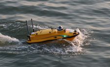
CHC Navigation (CHCNAV), a leading manufacturer of uncrewed surface vehicle (USV) technology, has introduced the Apache 3 Pro – an advanced compact hydrographic drone engineered for autonomous bathymetric surveys in...
This site uses cookies. By continuing to use this website, you agree to our Cookies Policy. Agree