Swathe Services Reseller of POS MV Products
Applanix Corporation has appointed Swathe Services to be an independent sales representative for the marine survey division of their company. This consists of all POS MV products including POS MV...
Applanix Corporation has appointed Swathe Services to be an independent sales representative for the marine survey division of their company. This consists of all POS MV products including POS MV...

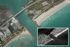
Current methods of shoreline mapping include aerial and high-resolution satellite imagery and ground-based surveying, all of which require considerable investment of human and material resources. Mapping and continuous updating of...
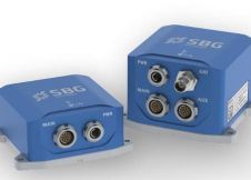
SBG Systems, France, has announced the Ekinox Series, a family of MEMS-based Tactical Grade Inertial Systems. This series consists of two ITAR Free models: the Ekinox AHRS which provides 0.05°...

This year’s Ocean Business conference had a busy programme. The traditional programme of trade show, live demonstrations and workshops is gaining more popularity among the hydrographic community. Ocean Business welcomed...
Applanix (Canada) has released firmware update version 6.24 for POS MVTM V5, the hydrographic georeferencing and motion compensation system. Customers under a valid product warranty agreement may download the...
From 12 March to 16 March 2012, RIEGL carried out an extended bathymetric test with the new VQ-820-G hydrographic airborne laser scanning system in South Florida, USA. With assistance from...

ProViewer, BlueView Technologies' 2D Imaging Sonar software now features video synchronisation and georeferencing for improved ROV operations and data review. The video synchronisation easily connects to the ROV's onboard video...

iMAR, a German manufacturer of inertial measuring systems for navigation, stabilisation, surveying, guidance and control for use in defence, surveying and industrial applications, launched its latest generation of ultra high...

Applanix has released POS MV V5 (Position and Orientation System for Marine Vessels), the next generation of its georeferencing and motion compensation system for hydrographic surveying. The system is available...
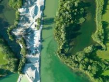
In order to meet the requirements of the European Water Framework Directive (EU-WFD), authorities face the problem of performing area-wide surveys of all kinds of inland waters repeatedly. Especially for...
This site uses cookies. By continuing to use this website, you agree to our Cookies Policy. Agree