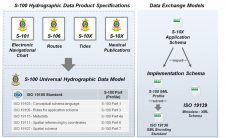
Imagery-derived Bathymetry and Seabed Classification Validated
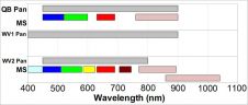
Proteus FZC, EOMAP and DigitalGlobe have formed a partnership to bring satellite-derived bathymetry and seabed classification to the hydrographic community. A pilot conducted by UKHO in the Mediterranean confirms that...