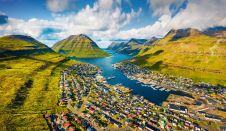
The challenges of surveying the Faroe Islands
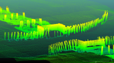
Crewless aerial mapping was recently chosen when surveying the Faroe Islands. For the small team, labour savings provided one advantage of a UAV-based approach. Another benefit was that clear skies...
Crewless aerial mapping was recently chosen when surveying the Faroe Islands. For the small team, labour savings provided one advantage of a UAV-based approach. Another benefit was that clear skies...

Qassim Abdullah, PhD, CP, PLS, is vice president and chief scientist at Woolpert. He has 40-plus years of industrial, research & development and academic experience in analytical photogrammetry, digital remote...
As the demand for elevation data continues to rise, it is important that users match the level of reliability, accuracy and resolution of the data to their specific application to...
This article presents a participative geomatics project with the goal of increasing southern Québec’s coastal communities’ ability to map and monitor changes in their coastal environment. Capacity-building and empowerment using...

Herjuno Gularso is a mapping surveyor at the Center for Marine and Coastal Environment Mapping at the Geospatial Information Agency. He received a Bachelor’s degree in Geodesy Engineering from Diponegoro...
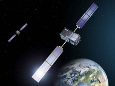
With spoofing attacks on the rise, survey-grade GNSS receivers need to be protected by interference mitigation technology utilizing the latest security techniques to ensure reliable positioning. The survey and mapping...
Hydrographers and data processors are expected to produce high-quality deliverables with a swift turnaround in this present age of data collection and technological refinement. However, the cost of proprietary commercial...
Panagiotis Agrafiotis holds a doctorate in Engineering from the National Technical University of Athens as well as an MSc in Geoinformatics and an MEng diploma in Surveying Engineering. His current...
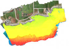
Accurate bathymetric mapping of shallow areas is essential for many offshore activities. Through Structure from Motion (SfM) and Multiview Stereo (MVS) techniques, images can provide a low-cost alternative compared to Lidar...
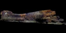
After 75 years, and using advanced imaging technology, ocean explorer Tim Taylor and his Lost 52 expedition team have officially discovered the final resting place of the 49 sailors of the...
This site uses cookies. By continuing to use this website, you agree to our Cookies Policy. Agree