Real-Time Long-range Detection Sonar
BlueView Technologies has launched a long-range imaging sonar with a wide field-of-view: the P450 Series, available in five models including two deep-water options. Each model has a maximum detection range...
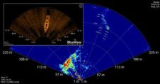
BlueView Technologies has launched a long-range imaging sonar with a wide field-of-view: the P450 Series, available in five models including two deep-water options. Each model has a maximum detection range...
Turner Designs introduces C-FINS (Fluorometric Integrated Nautical Mapping System), integrating the C3 Submersible Fluorometer's digital output with GPS data for data mapping. A simple software module enables C-FINS and ArcGIS...
A consortium comprising WFS Technologies, Swansea Metropolitan University and Valeport Ltd has delivered the world's first ad hoc distributed network of seabed sensors for measuring the effects of coastal erosion....
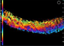
A further Echoscope system sale to a major construction contractor is reported by CodaOctopus Products, with the introduction of the sonar technology to a port expansion project in northwest Spain....

Real-time flooding and storm surge information is available as Tropical Storm Gustav approaches the Gulf Coast by visiting the interactive US Geological Survey (USGS) Water Hazards Map. The map provides...
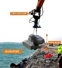
CodaOctopus Products is delivering Coda Echoscopes for deployment on various underwater construction projects to dredging company Van Oord. Two of three Echoscopes ordered by Van Oord have already been delivered...
The Danish Geodata Agency, alongside several collaborators, is currently conducting trials on the latest iteration of navigational charts in the Baltic Sea region. This initiative forms part of an EU-funded...

IHO standard S-44 is often used (or misused) to specify the quality of a hydrographic survey. While it is a useful tool, it is easy to misinterpret. One ‘misuse’ is...
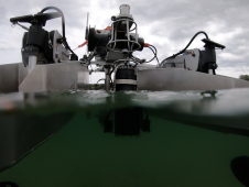
HydroSurv, a prominent provider of electric and hybrid uncrewed surface vessels (USVs), has successfully secured Innovate UK funding to advance the commercialization of an end-to-end seagrass monitoring solution. This endeavour...
As part of its Coastal Zone Monitoring Programme, the Marine Works Unit of the Dubai Municipality has set up a website (www.dubaicoast.org) which enables viewers to watch near real-time video...
This site uses cookies. By continuing to use this website, you agree to our Cookies Policy. Agree