Real-time Marine Monitoring Systems
The seas are being monitored, from satellite observations of the ocean surface to the growing number of in-situ measurement networks. The amount of information being generated is huge and should...
The seas are being monitored, from satellite observations of the ocean surface to the growing number of in-situ measurement networks. The amount of information being generated is huge and should...
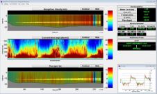
The NOAA National Ocean Service, Center for Operational Oceanographic Products and Services (CO-OPS) has installed a real-time wave/current measurement system in the Chesapeake Bay (MD, USA) using a bottom-mounted RD...
A 120-year-old mystery has been solved with the help of a CSIRO team aboard the RV Investigator. Heritage NSW has announced the discovery of the SS Nemesis, a 73-metre iron-hulled...

IIT Madras has established a Centre of Excellence (CoE) dedicated to advancing indigenous maritime technology and expertise. The team of researchers leading this initiative has been actively engaged in notable...

The Danish Geodata Agency, alongside several collaborators, is currently conducting trials on the latest iteration of navigational charts in the Baltic Sea region. This initiative forms part of an EU-funded...

IHO standard S-44 is often used (or misused) to specify the quality of a hydrographic survey. While it is a useful tool, it is easy to misinterpret. One ‘misuse’ is...
HydroSurv, a prominent provider of electric and hybrid uncrewed surface vessels (USVs), has successfully secured Innovate UK funding to advance the commercialization of an end-to-end seagrass monitoring solution. This endeavour...
The Mexico port authorities have enhanced their port security capabilities with the recent acquisition of nine advanced Oceanbotics SRV-8 professional underwater drones (ROVs). This strategic move aims to elevate their surveillance...
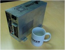
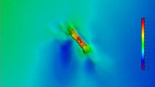
Sea acceptance testing of Kraken Sonar Systems' embedded real-time synthetic aperture sonar (RTSAS) signal processor for Australia’s Defence Science and Technology Organisation (DSTO) was a success. In real-time signal processing,...
PDT-H is Aqua Vision’s toolbox for the existing horizontal ADCP software suite, ViSea-H DAS. This toolbox lets the user quantify sediment concentrations and fluxes from horizontal ADCP data. PDT-H calculates...
This site uses cookies. By continuing to use this website, you agree to our Cookies Policy. Agree