Salman Bashit
Salman Bashit, an urban planning graduate from Khulna University in Bangladesh, is currently furthering his education in Geoscience at Mississippi State University. His academic and professional journey is marked by...

Salman Bashit, an urban planning graduate from Khulna University in Bangladesh, is currently furthering his education in Geoscience at Mississippi State University. His academic and professional journey is marked by...

In the quest to unravel the mysteries beneath our planet’s water bodies, topobathymetric technologies emerge as a beacon of innovation. Among them, Lidar (light detection and ranging) and sonar sensors...
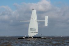
Saildrone announced the launch of its first aluminium Surveyor unmanned surface vehicle (USV) from the Austal USA production line in Mobile, Alabama. Chief of Naval Operations (CNO) Adm. Lisa Franchetti was...
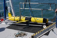
Exail’s DriX uncrewed surface vessel (USV) recently completed a first-of-its-kind fisheries research survey to assess the impact on biomass and fish stock before, during and after wind farm construction. Equipped...
Remote sensing of oil spills in conjunction with their prevention and combat has long since evolved into a key element for the protection of the marine environment. The impact of...

OceanWise has announced that, as of 1 November 2021, the RSOBIA toolbar is available free of charge. The software tool, which takes raster imagery and segments the data into geographic...
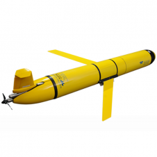
The Slocum glider is buoyancy-driven to enable long-range and duration remote water column observation for academic, military, and commercial applications. It can be deployed and recovered from any size vessel with minimal time on station The Slocum glider is buoyancy driven to enable long range and duration remote water column observation for academic, military, and commercial applications. The Slocum Glider can be deployed and recovered...

Argeo Robotics, a fully owned subsidiary of Argeo AS, has been granted a patent from the Norwegian Industrial Patent office (Patentstyret) for an advanced subsea electromagnetic remote sensing system. Argeo is...
A recent offshore exercise, conducted by Oil Spill Response Ltd. (OSRL, UK), was designed to understand how remote sensing technologies can help detect oil spills at sea more effectively. Utilising...
This site uses cookies. By continuing to use this website, you agree to our Cookies Policy. Agree