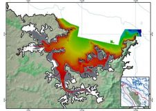
S-44 and the systematic error
IHO standard S-44 is often used (or misused) to specify the quality of a hydrographic survey. While it is a useful tool, it is easy to misinterpret. One ‘misuse’ is...

IHO standard S-44 is often used (or misused) to specify the quality of a hydrographic survey. While it is a useful tool, it is easy to misinterpret. One ‘misuse’ is...
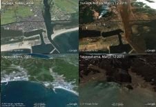
The impact of the catastrophic tsunami that inundated the coast of Japan in the aftermath of the 11th March earthquake is plain to see on comparison satellite images made before...
GPS Block IIA-10 (SVN-23), built by Boeing (formerly Rockwell Corporation), was launched on 26 November 1990 and set healthy to navigation and timing users on 10th December 1990. The satellite...
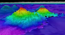
The crew of Schmidt Ocean Institute’s research vessel Falkor (too) recently discovered four underwater mountains – the tallest of which exceeds 2.4km in height – during a January transit from...

With innovation, progress and discovery at its heart, Oceanology International 2024 (Oi24) is preparing to welcome the world’s largest gathering of ocean professionals to the most powerful and inspirational event...
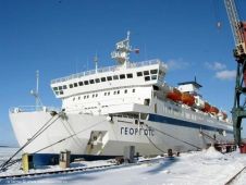
Russian ice-breakers using satellite images are escorting ferry boat Georg Ots through the Northern Sea Route. She is designed for navigation through ice and became the first passenger boat in...
From 21 to 25 January 2008, the 2nd International SAR oceanography workshop SEASAR-2008 was held in the ERS research institute ESRIN of the European Space Agency on the perspectives of...
Hopes are high that marine life previously unrecorded in New Zealand will be found during the second phase of the three-vessel Ocean Survey 20/20 Bay of Islands project. The survey...

SOUTH Marine Division, specializing in hydrography and marine survey, is actually a subsidiary of SOUTH Survey Group, a leading Chinese giant manufacturer in the geo-spatial industry. With 35 years of...
This site uses cookies. By continuing to use this website, you agree to our Cookies Policy. Agree