Baltic-wide Maritime Spatial Planning
The work on Maritime Spatial Planning (MSP) in the Baltic Sea region is being followed up and further advanced in an intensive two-day meeting in Helsinki, Finland. The MSP Working...
The work on Maritime Spatial Planning (MSP) in the Baltic Sea region is being followed up and further advanced in an intensive two-day meeting in Helsinki, Finland. The MSP Working...
On 14th December 2009, US' President Obama's Ocean Policy Task Force released its Interim Framework for Effective Coastal and Marine Spatial Planning (Interim Framework) for a 60-day public review and...
Ocean businesses gathered online to discuss the challenges and perspectives of marine spatial planning (MSP) in the North Sea region at a World Ocean Council (WOC) and Scottish Association for...
The Memorial University Fisheries and Marine Institute, USA, will inaugurate the new Master of Marine Studies in Marine Spatial Planning (MSP) and Management, the first graduate programme of its kind...
Future implementation of the European Union (EU) Directive on Maritime Spatial Planning (MSP) in the Baltic Sea region as well as exchange of MSP data were among the main topics...
England’s first ever plans for the future of our seas have been published on 2 April 2014. The marine plans – which provide guidance for sustainable development in English waters...

In May 2013 the HELCOM Secretariat received an unexpected email from Vietnam, asking for permission to translate the book Planning the Bothnian Sea into Vietnamese. Five months later, in October...
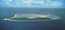
At the Eye on Earth Summit in Abu Dhabi last week, the Geographic Information System (GIS) software company Esri committed to building a database for the Cook Islands Marine Park...
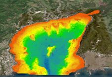
A deep understanding of seabed topography and coastal features is crucial for developing predictive models to address challenges such as coastal inundation and rising sea levels. Communities worldwide rely on...
Lidar, short for Light Detection and Ranging surveying, represents a sophisticated measuring system leveraging the power of light. Widely recognized for its versatility, Lidar is extensively applied in diverse fields...
This site uses cookies. By continuing to use this website, you agree to our Cookies Policy. Agree