Hydrography’s contribution to sustainable coastal planning
A deep understanding of seabed topography and coastal features is crucial for developing predictive models to address challenges such as coastal inundation and rising sea levels. Communities worldwide rely on vital marine environments, but the dynamic coastline presents an ongoing challenge. Hydrography is essential for coastal management and coexisting harmoniously with the sea, while also safeguarding the environment and addressing spatial planning. Explore our articles for in-depth insights into coastal mapping-related topics.
Towards a coastline base map in Indonesia
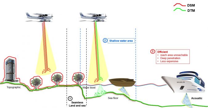
The determination of a sea or coastal area depends on the availability of coastline data, as is based on the coastline reference. The definition of the area of Indonesia’s sovereignty could be improved if it were based on accurate coastline data. Unfortunately, a coastline base map at a scale of 10,000 was only available for about 8% of the total of 108,000km of coastline in Indonesia in 2019. Shoreline data was therefore generated by integrating elevation data (Digital Elevation Model; DEM) for land and sea that was obtained by topographic and bathymetric surveys. However, the topographical conditions in Indonesia are unique, with shallow water characteristics. Furthermore, some of the coastal areas are inland seas that are difficult to access using technologies such as sounding sensors. An alternative method is therefore needed to accelerate the availability of coastline data in Indonesia that utilizes Lidar technology for bathymetry survey activities. Improving the availability of coastline data on a large scale is expected to benefit the national economy, in particular the maritime sector.
Sentinel-2 coastal charting worldwide
It is widely and wrongly assumed that the world’s coastal regions have been surveyed in detail by modern techniques and that the resulting nautical charts are an accurate reflection of the nature of the seabed. This optimistic approach is not shared by the world’s hydrographic offices or the International Hydrographic Organization (IHO). Hydrographers have a saying: “The world is fully charted, it’s a shame that so little is surveyed” and, one could add looking at venerable charts, so poorly surveyed.
Mapping the Catalan coast using airborne Lidar bathymetry
In collaboration with Field, ICGC contributed to a Catalan government initiative aimed at enhancing marine environment management. They employed airborne Lidar bathymetry (ALB) to survey the Catalan coastline, resulting in a precise topobathymetric elevation model. This model forms a foundational tool for effective coastal zone management. The Catalan coastal area is of immense importance for biodiversity and various human activities, including tourism, fishing and aquaculture. To further this cause, the Catalan government is developing a comprehensive ‘Map of Catalonia’s Marine Habitats’. This map will provide detailed cartography of the Catalan seabed, covering bathymetry, geomorphology, sedimentation and ecology. In doing so, it will unveil diverse habitats, species and their distribution. This knowledge is crucial for meticulous planning and sustainable management of the Catalan marine ecosystem, especially within the context of Natura 2000 protected areas and compliance with EU Directive 92/43/EEC for the conservation of natural habitats and wildlife.
Climate change: Kiribati’s efforts to address sea-level rise
The impacts of climate change and sea-level rise on daily life in Kiribati and the Pacific region can also be felt in the hydrographic profession. In this interview, Tion Uriam, the national coordinator for hydrography and charting in Kiribati, emphasizes the challenges faced by Pacific Island nations and the importance of addressing root causes. Uriam discusses the challenges in obtaining support and resources for the Kiribati Outer Islands Transport Infrastructure Investment Project, and how initiatives like Seabed 2030 are helping to bring together countries and organizations to share resources and expertise. Kiribati is also working to educate and raise awareness about the significance of hydrography and the effects of climate change.
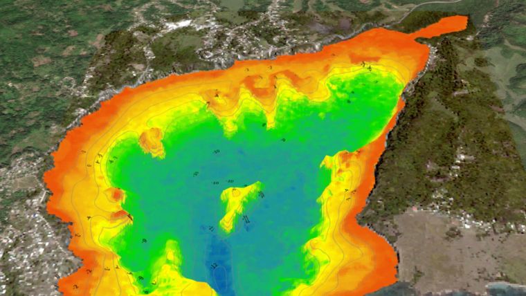
Satellite-derived bathymetry for surveying Jamaica’s coastal waters
Jamaica’s national land agency has integrated satellite-based hydrography into its hydrographic programme to enhance efficiency, reduce costs and boost safety in support of the country’s economic development. Across Central America and the Caribbean, the breathtaking coastal waters come with the challenge of managing natural resources while pursuing economic growth. Jamaica, under the SOLAS Convention, is responsible for conducting coastal hydrographic surveys. The National Land Agency (NLA), the nation’s designated hydrographic office, runs a survey programme to map Jamaica’s coastal bathymetry, fulfilling its duty to gather and share nautical data with stakeholders. The United Kingdom Hydrographic Office (UKHO) maintains Jamaica’s admiralty charts through a contractual agreement. This refined hydrographic data supports Jamaica’s national development, particularly in the context of the blue economy.


