Towards a coastline base map in Indonesia
Seashore large-scale mapping acceleration using Lidar bathymetry
The accuracy of coastline data in Indonesia could be much improved by making use of Lidar bathymetry technology. In this article, the authors describe how Lidar bathymetry survey techniques were applied to a section of coastline in the Sunda Strait.
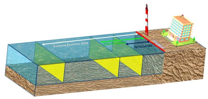
The determination of a sea or coastal area depends on the availability of coastline data, as it is based on the coastline reference (see Figure 1). The definition of the area of Indonesia’s sovereignty could be improved if it were based on accurate coastline data. Unfortunately, a coastline base map at a scale of 10,000 was only available for about 8% of the total of 108,000km of coastline in Indonesia in 2019. Shoreline data was therefore generated by integrating elevation data (Digital Elevation Model; DEM) for land and sea that was obtained by topographic and bathymetric surveys. However, the topographical conditions in Indonesia are unique, with shallow water characteristics. Furthermore, some of the coastal areas are inland seas that are difficult to access using technologies such as sounding sensors. An alternative method is therefore needed to accelerate the availability of coastline data in Indonesia that utilizes Lidar technology for bathymetry survey activities. Improving the availability of coastline data on a large scale is expected to benefit the national economy, in particular the maritime sector.
Airborne Lidar bathymetry
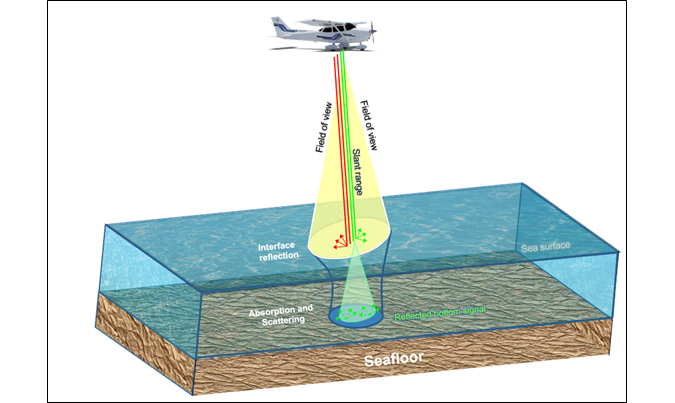
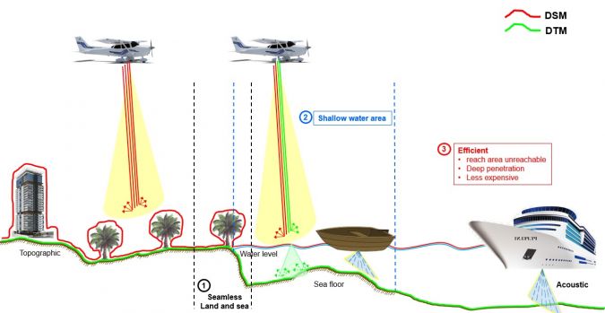
Lidar (Light Detection and Ranging) is part of a remote sensing system that uses active sensors and that works by comparing the characteristics of the transmission signal with its reflection; namely, the differences in pulse propagation time, wavelength and angle of reflection. In the Lidar bathymetry application, the laser used is a green light that can penetrate to the bottom of the water. When the laser hits the surface of the water, part of the laser wave is reflected and refracted in all directions and another part penetrates the water. The basic principles of Lidar bathymetry are shown in Figure 2.
Acquisition of Lidar bathymetry in Indonesia
To accelerate the availability of national coastline data, airborne Lidar bathymetry was conducted in 2020 around the Sunda Strait. A differential positioning method was used to provide an aircraft position with an accuracy of 10cm. All resulting positions were referred to the geodetic datum in Indonesia, SRGI2013. The altitude used was about 600m, and the distance between flight lines was 280m. A higher altitude can effectively increase the coverage area while maintaining the density of the point clouds, and Lidar acquisition can be carried out over a large area in a single flight. The capacity of the Lidar bathymetry acquisition was around 145km per day, with a total mapped coastline of 1,000km. Acquisition of Lidar bathymetry in the Sunda Strait reached a depth of up to 5m, because the measurement location was not fully in clear water. In this case, the Lidar bathymetry acquisition took just two months to complete the entire Area of Interest (AoI). Based on this capacity, the Indonesian archipelago could be mapped quickly; however, the biggest difficulty during data acquisition was the rainy season in the area around the Sunda Strait.
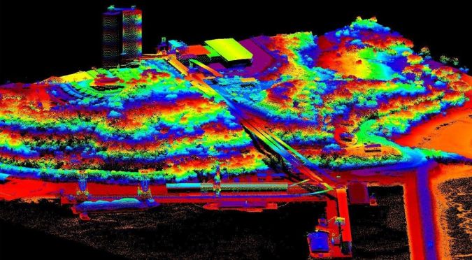
There are other difficulties in southern Java, as the region is dominated by high waves (high wave regime domination). In bathymetry surveys, the surface of the water is considered to be a horizontal plane of reflection where the laser beam refracts into the water based on the off-nadir beam angle. If the surface ripples, the laser will be refracted in all directions, changing the angle of incidence of the laser beam. This makes it difficult for laser to penetrate to the bottom of the water in such areas. The geometry of the beam path refracted from the laser under water therefore depends on the conditions of the water surface plane above it. An illustration of the DEM data extracted from the Lidar bathymetry measurement results can be seen in Figure 3. As this shows, objects around the coast can be mapped in detail, including the water area.
Level of detail of airborne Lidar bathymetry
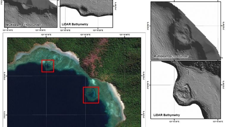
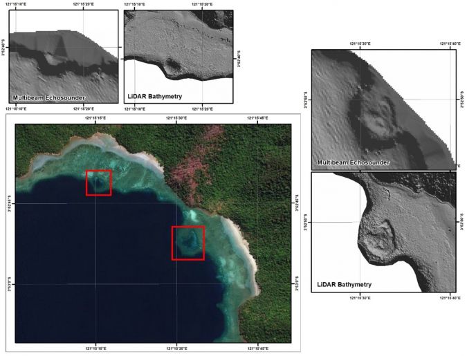
Lidar bathymetry uses infrared to produce land topography and green lasers to obtain the seabed. Therefore, Lidar bathymetry can produce a single seamless land and sea DEM, which greatly facilitates the data integration process as the resulting DEM is based on the same reference system. In addition, Lidar bathymetry can be conducted in areas such as shallow waters or coral reefs, which are difficult to survey using acoustic sensors, as can be seen in Figure 4. Figure 4 also shows that shallow water areas with corals are depicted very clearly using Lidar bathymetry, in contrast to multibeam which results in less detailed seabed mapping. Lidar bathymetry therefore produces high-resolution DEM data, making the extraction process of the shoreline easier.
Effectiveness of airborne Lidar bathymetry
Sounding technology has a capacity of about 50 line km per day when acquiring marine DEM data. Furthermore, the integration of marine and land DEM requires a time-consuming topographic measurement, and problems arise during the DEM integration process between land and sea due to the use of different technologies and different measurement conditions when collecting the data. In addition, there are problems due to the differences in the references used, so that the DEM elevation values are not the same. Although the depth results using a sounding sensor are very accurate, the sounding sensor cannot be used in shallow waters and inaccessible areas.
Lidar bathymetry can, however, acquire data over a large area in a single flight, making it highly efficient in terms of time. Its capacity for mapping coastlines is up to about 145 line km per day. For this reason, Lidar bathymetry is able to almost halve the survey time compared with the technology currently used. With such a capacity, the use of Lidar bathymetry for hydrographic survey activities provides many benefits, especially in terms of data acquisition cost efficiency. Therefore, Lidar bathymetry technology is very much worth considering as a method for accelerating the availability of a large-scale coastline map in Indonesia.
Accuracy assessment of Lidar bathymetry
An evaluation of accuracy was carried out to compare the accuracy of the DEM with the Lidar bathymetry measurement results. Furthermore, the z coordinates (both on land and part of the coast) were compared with field measurements using precise GNSS tools. The accuracy test was therefore carried out around the coast and in water areas that can be accessed using GNSS geodetic devices. The results of the accuracy evaluation show that the accuracy of the Lidar bathymetry measurement is 0.3m with a 90% confidence level. These results are in accordance with vertical accuracy standards in Indonesia. Lidar bathymetry results can therefore be used to produce maps at a scale of 1:5,000.
Conclusion
Lidar bathymetry surveys are very effective in shallow water locations and inaccessible areas, such as in archipelagic areas in Indonesia. Another advantage is that Lidar bathymetry produces seamless DEM, making it easy to integrate land data with marine data. In addition, the high altitude flight range of the aircraft means that the Lidar bathymetry survey has a large coverage area in a single flight. These advantages can help to accelerate the availability of a coastline base map in Indonesia.
It should be noted that the success of a bathymetry Lidar survey is highly dependent on the ability of the green laser to penetrate the water column. For this reason, bathymetric Lidar surveys depend on environmental conditions such as water turbidity, the water surface plane and weather conditions. Lidar bathymetry is therefore highly suitable for use in areas of Indonesia with clear and calm waters that are influenced by non-dominant sediment processes. However, the penetration ability of the Lidar bathymetry system to the bottom of the water column decreases in coastal areas with poor water quality, so that data collection needs to be done using sounding sensors and terrestrial methods. This combination of technologies obtains maximum results.

Value staying current with hydrography?
Stay on the map with our expertly curated newsletters.
We provide educational insights, industry updates, and inspiring stories from the world of hydrography to help you learn, grow, and navigate your field with confidence. Don't miss out - subscribe today and ensure you're always informed, educated, and inspired by the latest in hydrographic technology and research.
Choose your newsletter(s)


