Rising tides: exploring the expanding horizons of bathymetric Lidar applications
In this article, we examine the evolving landscape of bathymetry with insights from Anders Ekelund, vice president of airborne bathymetric Lidar at Hexagon Geosystems. Beyond mapping seagrass, Ekelund unveils Lidar’s pivotal role in addressing climate-driven challenges, from coastal management to flood prediction. Anticipating a shift towards full waveform data analysis, he emphasizes Hexagon’s expertise in efficiently mapping shallow waters. Experience the precision of airborne Lidar, which is reshaping our comprehension of coastal and underwater environments.
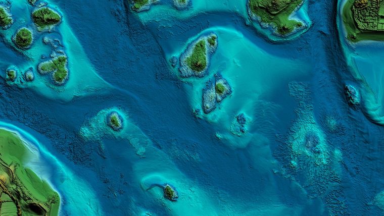
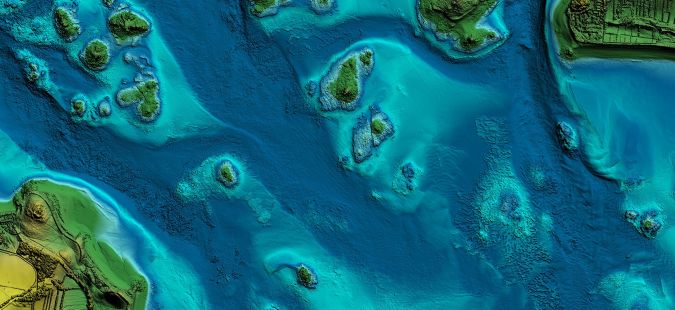
How do you map a seagrass meadow?
An area the size of a football field of seagrass is estimated to disappear every half hour, with huge implications for the planet. The carbon storage potential of seagrass, which can store carbon in its roots several metres deep, is much more powerful than that of forests. Preserving this habitat is therefore essential for climate change mitigation. How do we know that a football field-sized area of seagrass is disappearing every half hour? The truth is that we don’t. Mapping seagrass is complex, and to accurately assess how much of it is disappearing we must map it regularly.
There is therefore an increasing need for the systematic and accurate mapping of seagrass meadows, which will enable the development of sustainable business models, by tracking the disappearance and regrowth of vegetation that sequesters carbon into the seabed over time. Hexagon’s sustainable investment subsidiary R-evolution has been working with the non-profit organization Beneath The Waves and the government of The Bahamas to create a scalable method for mapping seagrass meadows. Using Leica Geosystems’ bathymetry solutions, they have produced multidimensional, intelligent maps to assess the density of the seagrass ecosystem and its carbon storage potential.
Climate change drives the need for bathymetry
Blue carbon (the carbon captured by the world’s ocean and coastal ecosystems) is not the only space where bathymetry contributes to tackling urgent environmental challenges driven by climate change. Approximately 40% of the global population lives near the coast, so that coastal erosion, rising sea levels and natural disasters such as hurricanes, tsunamis and storm surges threaten many communities and populations. In fact, complete small island nations may disappear due to global sea-level rise. Bathymetric surveys are essential for optimizing urban developments, protecting new and existing infrastructure and coastal resource utilization planning.
Inland too, bathymetric solutions are key for river mapping and flood simulations. Climate change forecasts predict a ninefold rise in the frequency and up to a 19% increase in the intensity of rainfall in Western Europe. Bathymetry data from riverbeds, combined with drainage models derived from topographic Lidar, helps develop advanced flood risk analyses and early flood warning systems from weather forecasts that will proactively safeguard communities and critical infrastructure.
Some countries are responding to the need for data-driven flood prediction and mitigation by employing bathymetry. In some regions, airborne topographic/bathymetric data solutions are integrated with boat-based multibeam solutions to form a seamless model from deep water to land. This integration facilitates advanced flood modelling solutions, and more countries are likely to adopt similar approaches in the future.
Innovation begets innovation
Continuous technological advancements are reducing the costs of the technology itself, as well as that of individual projects. Ongoing hardware and software innovations have resulted in notable enhancements in material efficiency, depth penetration and data density. Crucially, systems such as the Leica Chiroptera-5 and the Leica HawkEye-5 empower real-time data monitoring during aerial operations and enable operators to assess data quality at an early stage. Naturally, declining costs will translate into market growth.
Another driver of market expansion is the emergence of new opportunities within enhanced analysis capabilities. The fast development of AI and machine learning has the potential to create new and improved methods for data classification. Hexagon uses AI, for example, for intelligent carbon mapping in its Blue Carbon project. Many more applications are conceivable, especially considering the wealth of available data.
Shifting focus from point clouds to waveform data
The Lidar industry traditionally focuses on point cloud data, where we quantify accuracy in terms of the number of points delivered. However, full waveform Lidar not only measures discrete points; it records how a laser beam interacts with various surfaces and objects within its illuminated area. In the case of bathymetric Lidar, for instance, the laser interacts with the water’s surface texture, particles, dissolved substances and seabed structure. The resulting scattered signal includes more information than just the location of the water surface and seabed.
Intelligent focus and separation algorithms allow the extraction of this information. As the laser hits an object (e.g. the seafloor or particles in the water) and reflects towards the sensor, it creates a complex waveform pattern that the sensor captures and records. This full waveform data provides a comprehensive, detailed record of how laser pulses interact with underwater surfaces and objects.
Waveform data lends itself to in-depth analysis and interpretation, providing a more comprehensive understanding of the underwater landscape. Currently, full waveform algorithms are available that improve depth penetration, accuracy and performance in turbid waters and enhance object detection and overall survey results in shallow water, but this is only the beginning.
Extracting the information beyond the point cloud and thus exploring the possibilities of full waveform analysis is still in its early stages, with incredible potential to be uncovered. Ongoing enhancements in processing capabilities, along with advancements in machine learning and AI, will drive the industry’s ability to analyse full waveform data, and we can expect the discovery of new insights and applications in bathymetry.
Bathymetric systems are already proving their value in important applications and will become an even more powerful tool for coastal management, habitat mapping, coastal resilience and environmental conservation. Data is seamlessly fused with data from other sensors, such as high-resolution imaging, hyperspectral data, multibeam data, satellite data, in the water column captured data and seabed ground-truth in-situ data. The combination of different data sources, from the finest resolution data captured at high cost in the water to the lower resolution data from space, enables the efficient scaling of new applications. Airborne bathymetric Lidar plays a crucial role in this ‘triangle of trust’ by offering the highly cost-effective mapping of shallow waters at high accuracy on a large scale, providing a seamless transition through the land and water interface like no other existing technology.

Value staying current with hydrography?
Stay on the map with our expertly curated newsletters.
We provide educational insights, industry updates, and inspiring stories from the world of hydrography to help you learn, grow, and navigate your field with confidence. Don't miss out - subscribe today and ensure you're always informed, educated, and inspired by the latest in hydrographic technology and research.
Choose your newsletter(s)


