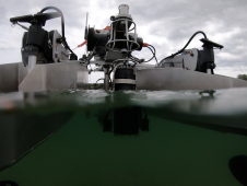
S-44 and the systematic error
IHO standard S-44 is often used (or misused) to specify the quality of a hydrographic survey. While it is a useful tool, it is easy to misinterpret. One ‘misuse’ is...

IHO standard S-44 is often used (or misused) to specify the quality of a hydrographic survey. While it is a useful tool, it is easy to misinterpret. One ‘misuse’ is...
HydroSurv, a prominent provider of electric and hybrid uncrewed surface vessels (USVs), has successfully secured Innovate UK funding to advance the commercialization of an end-to-end seagrass monitoring solution. This endeavour...
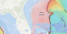
A groundbreaking study has unveiled the discovery of an immense coral reef on the bottom of the Atlantic Ocean, marking the largest deep-sea coral reef ever measured. Spanning approximately 26,000...
Kongsberg Maritime, Norway, has been awarded the contract to supply a survey suite to a vessel currently under construction and for use by a consortium of German universities. The universities...
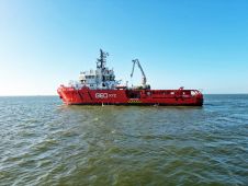
The acquisition of the offshore survey vessel Geo Ocean VI marks the next step in the expansion of the offshore survey capacities of GEOxyz, the Belgium-based geodata specialist. With a...

The GeoSwath Compact Survey Vessel (CSV) is being shown for the first time at this week's Ocean Business (located on the dockside). The first-ever Kongsberg-developed survey vessel integrates all the...

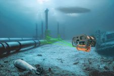
Fugro will acquire the vessel KV Tromsø from Kystvaktskipet Tromsø of Norway. This vessel will be converted initially for acoustic pipeline inspection survey operations and will be ready for deployment...

Woolpert has acquired eTrac, a vessel-based hydrographic survey and marine technology firm that conducts custom and integrated marine services for projects across the U.S. and its territories. These marine services...

Associated British Ports (ABP) has awarded Blyth Workcats the contract for a new 14-metre survey vessel to be built at the company’s yard on Canvey Island, UK. The boat will...
The esteemed Finnish Geospatial Research Institute (FGI) is set to utilize advanced Lidar systems developed by the Fraunhofer Institute for Physical Measurement Techniques IPM for future maritime surface surveys. Anticipating...
This site uses cookies. By continuing to use this website, you agree to our Cookies Policy. Agree