An Introduction to EGS
From modest beginnings with just a handful of employees in Hong Kong and the United Kingdom twenty-eight years ago, the EGS Group has now grown into an international group of...
From modest beginnings with just a handful of employees in Hong Kong and the United Kingdom twenty-eight years ago, the EGS Group has now grown into an international group of...
Port Hercule in the Principality of Monaco has been extended, in 2002, with a floating breakwater and a counter-jetty which have considerably augmented the reception capabilities of it. The vocation...
Airborne Electro Magnetic Bathymetric (AEMB) mapping is useful in turbid and surf-zone waters where lidar systems are not fully effective. Coastal areas of hydrographic importance containing turbidity, shoals and channels...
To support the production and maintenance of navigational charts, the United Kingdom Hydrographic Office (UKHO) receives large quantities of bathymetric data from a great number of sources. This data is...
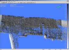
The next step in the presentation of hydrographic survey data is the integration of separate data sets into navigable three-dimensional models. Software tools now available allow contractors to produce geo-referenced...
In spite of modern communications and connections by air, Japan still is for most people from Europe and America, a ‘far away country’. Hydro international is in the fortunate position...
Matthew Fontaine Maury is probably the best known of all hydrographers, and the most celebrated both in his homeland, the United States of America, and in Europe. He served for...
Matthew Fontaine Maury is probably the best known of all hydrographers, and the most celebrated both in his homeland, the United States of America, and in Europe. He served for...
Laser scanning and bathymetric side-scan sonar represent the cutting edge of environmental survey technology. Over the last few years, we have tested the integration of these two methodologies, carrying out...
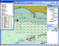
Specially adapted Kongsberg Norcontrol IT C-Scope software formed the platform for an in- depth MarNIS (Maritime Navigation and Information Services) demonstration, held at the MCA's Highcliffe Training Centre on 13...
This site uses cookies. By continuing to use this website, you agree to our Cookies Policy. Agree