UKHO Conducts Seabed Mapping in Belize
The United Kingdom Hydrographic Office (UKHO) has deployed two vessels to survey the waters of Belize as part of the Commonwealth Marine Economies (CME) programme. Following a stakeholder meeting with the Belize Port Authority and wider government earlier this month, priority areas will be surveyed, capturing sonar data of Belize's main ports and approaches.
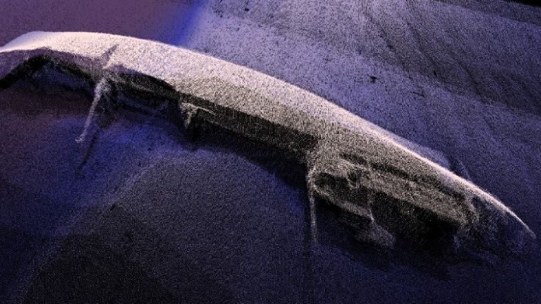
High-frequency mapping sonars are being used, which have no negative impact on an area's diverse ecosystems and marine life. The surveying is expected to continue throughout February and will focus on areas including Belize City, Big Creek and Commerce Bight.
Updated charts
Information from the survey will be used to update nautical charts of the region, as well as helping Belize to meet its international maritime obligations, including respective elements of the Implementation of IMO Instruments Code (IIIC). These updated charts will reduce navigational risk and improve the safety of ships, cargo and crew. Data will also support a range of environmental and scientific applications, enabling Belize to better manage the marine environment in these areas.
By supporting safe navigation in the region, it is expected to bring economic benefits to Belize by encouraging access for its growing cruise ship sector, and maximising efficiency of trade by enabling ships to confidently increase cargo-carrying capacity.
Coastal management
All data will be made available to the Belize Port Authority and wider government once it has been processed and validated by teams at the UKHO. The data could also bring environmental benefits to the state, by facilitating the sustainable management of fisheries and other marine resources, as well as supporting coastal protection and management.
This work forms part of the CME Programme, a programme delivered on behalf of the UK Government by the UKHO, the Centre for Environment, Fisheries and Aquaculture Science (Cefas) and the National Oceanography Centre (NOC). The programme aims to support the sustainable growth of Commonwealth Small Island Developing States (SIDS) by making the most of their natural economic and environmental resources.

Value staying current with hydrography?
Stay on the map with our expertly curated newsletters.
We provide educational insights, industry updates, and inspiring stories from the world of hydrography to help you learn, grow, and navigate your field with confidence. Don't miss out - subscribe today and ensure you're always informed, educated, and inspired by the latest in hydrographic technology and research.
Choose your newsletter(s)


