Seabed Selects Velodyne Sensors for Mobile Mapping System
Seabed B.V., which specializes in high-quality equipment for offshore surveying and dredging, has selected Velodyne Lidar’s Puck sensors for its Lidar mobile mapping system. The Seabed system is a turnkey mobile Lidar solution for hydrographic surveys and can support sustainable planning, which aims to protect sensitive historic and marine environments.
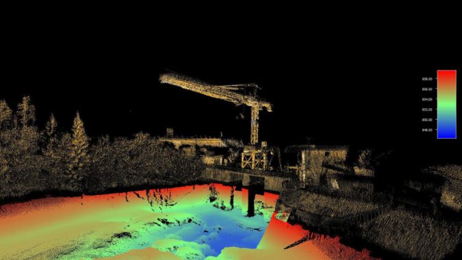
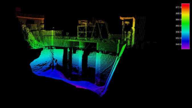
The Seabed Lidar system, equipped with a Puck sensor, provides complete above-water point cloud data and can operate in harsh maritime conditions. The system conducts 3D data capture of intricate measurements of inshore, nearshore and inland waterways from up to 100 metres away. It is designed to be simple to mobilize and easy to use without the need for specialized training or qualifications, delivering rapid results that can save time and money.
3D Georeferenced Image Above and Below Water
The Seabed Lidar system can be combined with a bathymetric multibeam echosounder to provide a complete 3D, georeferenced image above and below water. The data can be used to rapidly inspect the structural integrity of bridges, dams and piers, and can be a resource for preservation and sustainability planning. Regular inspections of bridges and waterways are also important to improve navigation safety, especially in high traffic areas where the depth is shallow.
“We selected Velodyne’s Puck because it produces the high-quality, consistent data our customers need,” said Elice Collewijn, general manager, Seabed, which is based in Amsterdam, The Netherlands. “The Puck has demonstrated outstanding reliability and power efficiency while operating in severe offshore situations. The sensor allows us to capture vital, high-resolution data to accurately measure and analyse marine environments.”
Offshore 3D Mapping Solutions
“Seabed is helping companies transform their businesses with offshore 3D mapping solutions which can deliver highly accurate, detailed data collection to support safe navigation and protection of marine environments,” said Erich Smidt, executive director Europe, Velodyne Lidar. “Their solutions demonstrate how Velodyne’s sensors provide the performance, range and compact form factor needed for versatile mobile mapping systems that can enable a sustainable future.”
The Velodyne Puck sensors are recognized for their ability to deliver a high-resolution image to measure and analyse a variety of environments. They provide high-quality resolution and performance along with a full 360-degree environmental view to provide real-time 3D data. The power efficiency advances the travel range and sustainability of applications.