Found 803 results
Sort by

ESRI Mapping Center Improving Maps

ESRI has launched Mapping Center, a new website that helps users learn about cartographic concepts and best practices for mapmaking with ArcGIS. The site is designed to provide quick answers...

Read more

Hydrographic Information Databases

The availability of various sensors and sophisticated technology providing digital data means that today’s hydrographers must attune to the idea that the final products should be available in a hydrographic...

Read more

MESH Maps Come Online

An international team of scientists, working over the last four years, has developed a framework for Mapping European Seabed Habitats (MESH). The project achievements far exceeded those originally planned, and...

Read more

Google Earth Meets the Sea

Google Earth and its related layer language Keyhole Markup Language (KML) have taken the mapping world by storm. Combining an approachable user interface, high-quality satellite imagery, and free cost (for...

Read more

Marine SDI

Global warming, climate change, rising sea levels and increased commercial exploitation of the seabed and sea space are important global indicators of a changing world environment. A crucial role is...

Read more

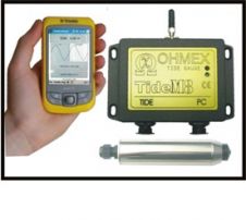
Bluetooth Tide Gauge

TideM8 is a combination of the Ohmex TideM8 miniature tide gauge system and Trimble's Juno hand-held Mobile PC with integrated GPS. The system is a new design based on the...

Read more

Morphology and Geohazard Surveys

To identify geohazards and constraints for seabed infrastructure, the data from various types of survey of the seabed and sub-seabed such as bathymetry, seabed morphology, geology, geotechnical and environmental can...

Read more