Salman Bashit
Salman Bashit, an urban planning graduate from Khulna University in Bangladesh, is currently furthering his education in Geoscience at Mississippi State University. His academic and professional journey is marked by...
Salman Bashit, an urban planning graduate from Khulna University in Bangladesh, is currently furthering his education in Geoscience at Mississippi State University. His academic and professional journey is marked by...

Oceanology International 2024 (Oi24) is set to captivate attendees with a showcase of pioneering companies and innovative technologies, all poised to command attention at London's ExCeL. From advanced autonomous vehicles...
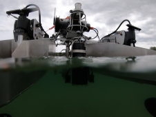
HydroSurv, a prominent provider of electric and hybrid uncrewed surface vessels (USVs), has successfully secured Innovate UK funding to advance the commercialization of an end-to-end seagrass monitoring solution. This endeavour...
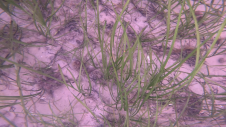
Seagrass meadows play an invaluable role as critical ecosystems that contribute significantly to marine biodiversity, carbon sequestration and coastal protection. In recent years, the importance of these underwater habitats has...
Whenever new objects have to be created, be it on or below the land and water, construction plays a role. The construction process often starts with surveying, either [marine surveying]...
On 24 January 2023, the European Union declared the Galileo High Accuracy Service (HAS) operational for testing, and it is scheduled to become fully operational in 2024. This free signal adds...
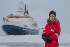
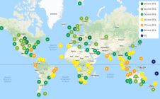
After eventful and busy months, the Arctic season of the ArcWatch-1 Polarstern expedition ended this weekend. The team of almost 100 crew and scientists measured sea ice thickness and properties,...
Andrijana Horvat is R&D lead geophysicist and GIS specialist at Hidrocibalae, with a Master’s in Geography from the University of Zagreb. Her professional interests include hydrography, GIS, Python programming and cartography,...
Srećko Kajić is reporting lead and GIS engineer at Hidrocibalae, with a Master’s in Geography from the University of Zagreb. His professional interests include GIS, cartography, hydrography and spatial planning,...
Unmanned surface vehicles (USVs) are increasingly being used for the mapping and management of shallow-water environments such as lagoons, rivers and estuaries, due to their economic and ecological benefits. The...
This site uses cookies. By continuing to use this website, you agree to our Cookies Policy. Agree