ThinkGeo Announces The Release Of TIGER 2005 SE
ThinkGeo released TIGER 2005 Second Edition in Shapefile format. TIGER 2005 SE offers GIS developers an access the latest and most complete set of United States geographic data from the...
ThinkGeo released TIGER 2005 Second Edition in Shapefile format. TIGER 2005 SE offers GIS developers an access the latest and most complete set of United States geographic data from the...
MAPPS, an association of geospatial, mapping and photogrammetry companies in USA, has added fifteen new member firms – now reaching more than 160 member and associate member firms. This number...
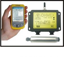
TideM8 is a combination of the Ohmex TideM8 miniature tide gauge system and Trimble's Juno hand-held Mobile PC with integrated GPS. The system is a new design based on the...
MAPPS has introduced the Geospatial Products and Services Excellence Awards. This new annual awards programme will recognise the professionalism, value, integrity and achievement of MAPPS member and associate member firms...
Monfils, R., Gilbert, T. and Nawadra S., 2006.Ocean & Coastal Management Selected Papers from the East Asian Seas Congress 2003, Putrajaya, Malaysia, 49: pp 779-788.Oil, chemicals and unexploded ordinances onboard...
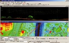
This paper describes the development of a web spatial image server used for sharing huge sets of georeferenced coastal orthophotos on the web via an easy visualisation interface. Traditional cartography...
Merrick & Company has made available MARS FreeView, an intuitive, easy-to-use viewing application for LiDAR, high-resolution imagery and GIS datasets for free download. The application has several visualization tools and...
Shipping lines operating in Malaysian waters can now take advantage of new official digital chart coverage just released through the British Admiralty raster chart service ARCS. The 32 new ARCS...
To identify geohazards and constraints for seabed infrastructure, the data from various types of survey of the seabed and sub-seabed such as bathymetry, seabed morphology, geology, geotechnical and environmental can...
Under the 1982 United Nations Convention on the Law of the Sea (UNCLOS) coastal states may claim rights over the resources of the sea and seabed up to 200 nautical...
This site uses cookies. By continuing to use this website, you agree to our Cookies Policy. Agree