Think Big for Coastal Mapping
“Think big for coastal mapping” is the foremost advice that Don Ventura of Teledyne Geospatial would impress upon agencies interested in bathymetric Lidar. “It’s a matter of efficiency of scale.”...
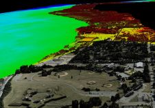
“Think big for coastal mapping” is the foremost advice that Don Ventura of Teledyne Geospatial would impress upon agencies interested in bathymetric Lidar. “It’s a matter of efficiency of scale.”...

The transition to autonomous marine operations is a promising process in full swing. The advantages of carrying out hydrographic or oceanographic tasks autonomously weigh heavily against the traditional methods. Global...

Capturing and measuring the environment in the Arctic and Antarctic is a particularly challenging job. The area of interest is often covered by a thick blanket of snow and ice,...
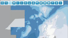
OceanWise, a renowned provider of marine and coastal mapping worldwide, has been awarded the framework agreement for the provision of GIS marine data to the Scottish Government until 2026. Janet...
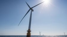
Crown Estate Scotland has announced the results of the ScotWind seabed tender, in which they auctioned 8,600km² of sea space. Under the popular tender, 74 bids were received for the...
As the demand for elevation data continues to rise, it is important that users match the level of reliability, accuracy and resolution of the data to their specific application to...
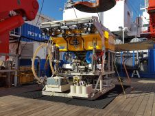
Scientists of the JPI Oceans project ‘MiningImpact’ are embarking on a six-week expedition to the Clarion-Clipperton Fracture Zone in the Pacific. Their goal is to carry out independent scientific monitoring...
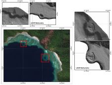
The accuracy of coastline data in Indonesia could be much improved by making use of Lidar bathymetry technology. In this article, the authors describe how Lidar bathymetry survey techniques were...
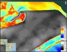
Submarine groundwater discharge (SGD) is a significant part of the water cycle that delivers anthropogenically derived and naturally occurring nutrients to coastal waters. As part of the drive to develop...
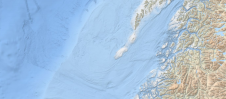
Bathymetry, the topography of the seafloor, is a fundamental feature of the ocean. Accurate bathymetric data is the foundation for much of ocean science and policy. For example, nautical charts...
This site uses cookies. By continuing to use this website, you agree to our Cookies Policy. Agree