Crowdsourced Mapping from Boats Featured on the BBC
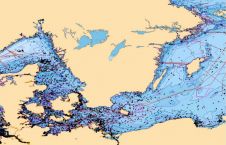
The BBC has filmed a report on Teamsurv and how OceanWise will potentially use Teamsurv data to improve OceanWise’s Seabed Digital Elevation Model (DEM). Large parts of the seas around...

The BBC has filmed a report on Teamsurv and how OceanWise will potentially use Teamsurv data to improve OceanWise’s Seabed Digital Elevation Model (DEM). Large parts of the seas around...
The Coastal Zone Mapping and Imaging Lidar (CZMIL) won a Geospatial World Technology Innovation Award at the Geospatial World Forum on 8 May 2014, in Geneva, Switzerland. It earned recognition...
ChartWorld, Germany, offers the OceanWise Marine Themes dataset combining the fragmented features of traditional nautical charting merged into an almost seamless marine map. The resulting data is more beneficial and...
A consortium consisting of Royal Boskalis Westminster N.V. (Boskalis), Van Oord, NMDC (Abu Dhabi) and Jan de Nul (Belgium) has acquired a contract from the Suez Canal Authorities, in connection...
The North Sea Canal connects the Port of Amsterdam with the sea. The two breakwaters at the mouth of the harbour in IJmuiden, The Netherlands, are usually monitored on displacement...
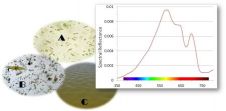
Natural water colour measurements are based on multi- and hyper-spectral measurements performed in the field and from space. A simpler approach to determine the colour of natural waters is by...

Members of the Hydrographic Society Benelux (HSB) and the Deutsche Hydrographische Gesellschaft (DHyG) travelled to the island of Terschelling for a two-day workshop packed with presentations on the profession, standards...

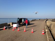
There are settings where an unmanned survey represents more than a safe, cost-effective alternative; it may be the only option. Capitol Lake in Olympia, WA, USA, is such a location....
OceanWise, UK, has released free, interactive Marine Mapping product demonstrators. Built using OpenLayers, the demos allow the user to pan around a defined area and get a feel for different...
AXYS Technologies has signed a definitive agreement to acquire 100% of the FLiDAR shares. Together, AXYS and FLiDAR will be a leading supplier of floating Lidar systems worldwide. AXYS has...
This site uses cookies. By continuing to use this website, you agree to our Cookies Policy. Agree