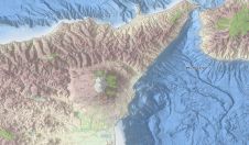
The study of mapping the seafloor
This article will immerse you in the deep water of bathymetry. It explains in detail what a bathymetric map is, what it shows, what methods we use to collect the...
This article will immerse you in the deep water of bathymetry. It explains in detail what a bathymetric map is, what it shows, what methods we use to collect the...
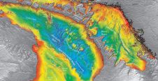
An upgraded version of the EMODnet Bathymetry digital terrain model (DTM) for the European Seas has just been released. This bathymetry product now offers higher resolution, powerful 3D visualisation functionality...

Oceanology International 2018 features an EMODnet Bathymetry Workshop which will provide an overview and demonstrations of the current portal and interactive services for viewing and downloading the harmonised EMODnet Bathymetry...

Gottfried Mandlburger studied geodesy at TU Wien, where he also obtained his Ph.D. in 2006. After finishing a 3-years research stay at the University of Stuttgart (2017-2019), he returned to...
The Port of Rotterdam is a leading global port and by far the largest seaport in Europe. The port is situated in the Rhine delta and with its direct connection...
Starting in 2005, the French Naval Hydrographic and Oceanographic Office (Service hydrographique et océanographique de la marine [Shom]) and the French National Geographic Institute (Institut National de l’Information Géographique et...

Dr. John K. Hall began his career at WHOI (1962-65) and then did his Ph.D. at Columbia University's Lamont-Doherty Geological Observatory from a drifting ice station in the Arctic Ocean. In...
The EMODnet DTM with digital bathymetry for all European waters has again been updated in the last year and is now publicly available for browsing and downloading from the portal....
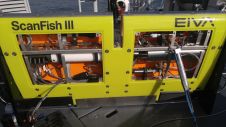
Using two vessels and a wide array of oceanographic sensors, the City of San Diego, California, USA, continually inspects and reports on two wastewater outfalls: Point Loma Ocean Outfall (PLOO)...
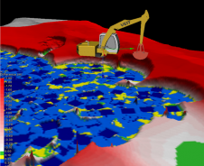
Veit, US-based specialty contractors that use Trimble software and hardware on their wide-ranging excavation and dredging projects, found themselves in need of 3D software visualisation in an upcoming dredge project...
This site uses cookies. By continuing to use this website, you agree to our Cookies Policy. Agree