Atlantis Initiative Online
The Atlantis Initiative, a collaborative project that is working on ways to provide better information to address the impact of climate change and flood risks, is now live on the...
The Atlantis Initiative, a collaborative project that is working on ways to provide better information to address the impact of climate change and flood risks, is now live on the...
Mesuris SA was founded in France in July 1993 with its main initial purpose being the distributor of survey equipment within France. The company headquarters are in St Grégoire France,...
The Military Survey Department of the Armed Forces is the sole federal mapping agency and entity in the United Arab Emirates (UAE). It is responsible for co-ordinating, processing and disseminating...
Triton Imaging, Inc., in collaboration with its Southeast Asia Representative HYDRONAV Services and their associated representative office in Jakarta PT Hidronav Tehnikatama, participated in the installation and commissioning of two...
Elettra TLC, a subsidiary of Telecom Italia, has equipped their Cableship Teliri with the latest release of Makai's suite of submarine cable planning and installation software. The upgrade package included...
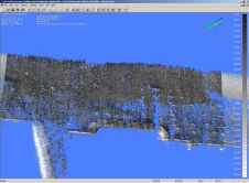
Laser scanning and bathymetric side-scan sonar represent the cutting edge of environmental survey technology. Over the last few years, we have tested the integration of these two methodologies, carrying out...
A novel collaboration between maritime Local Authorities in south-east England is providing important new information on the coastal region to aid future decisions concerning the management of the coast. The...
After working for eighteen years with the trailer department of a dredging company, Stef Mars started his own hydrographic survey company in 1985. Working on board of hopper trailer suction...
The hydrographic community has tumbled headlong into a data boom. Hundreds of single-beam soundings are now replaced by millions of high-resolution multi-beam swath soundings. This boom is not free from...
The Hydrographic Institute of Portugal (HIP) has been executing hydrographic surveys at the port of Sines since 1973 as part of successive contracts signed with the Port of Sines Authority....
This site uses cookies. By continuing to use this website, you agree to our Cookies Policy. Agree