Found 751 results
Sort by

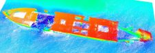
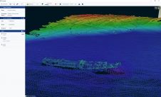
Automatic calibration for MBES offsets

Currently, calibration of multibeam echosounders (MBES) for hydrographic surveys is based on the traditional ‘patch test’ method. This subjective method, although rigorous, has major drawbacks, such as being time-consuming (in...

Read more

Using the Apache Unmanned Survey Vessel

This paper explores the various features of the Apache USV series for efficient seafloor-level mapping. The CHCNAV hydrographic survey software is used for data recording and analysis. It provides results...

Read more

“Blue technology industries will help the expansion of the hydrographic market”

In the last decade, there has been a steady march towards the automation of hydrographic data collection. Jim Gardiner, a research scientist at Valeport, views the technical and commercial challenges in hydrographic operations. In the last decade, there has been a steady march towards the automation of hydrographic data collection. Jim Gardiner, a research scientist at Valeport, views the technical and commercial challenges...

Read more

Dylan Colson

Dylan Colson is an Australasian Certified Professional Hydrographic Surveyor at Level 1. With over ten years’ experience in the industry, working mainly in the ports and dredging sectors, Dylan has...

Read more

Navigate Hydrographic – the Nautical SmartChart

What is the core role of a hydrographer? To map the seafloor? Provide a precise position on the water? Some may believe it is to play with lots of expensive toys on boats, while colleagues are stuck in the office. While all those answers may be correct, I am asking about the core role of a hydrographer. I would suggest that it is collecting data to provide information that companies, clients and consultants rely on to make educated and accurate decisions. This is where our value as a professional service is demonstrated. However, here is another question – how do we present that information and, more to the point, could it be better? What is the core role of a hydrographer? To map the seafloor? Provide a precise position on the water? Some may believe it is to play with lots of expensive...

Read more