Coastal Risk Assessment
SHOM contributes routinely to the preparedness against coastal risks along French coastlines. For this purpose, regional to coastal digital elevation models are built for implementation in forecast systems against rapid...
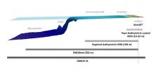
SHOM contributes routinely to the preparedness against coastal risks along French coastlines. For this purpose, regional to coastal digital elevation models are built for implementation in forecast systems against rapid...
The key objective of NOAA’s ENC Training Programme is to educate Hydrographic Offices (HOs) on ENC workflow in the Office of Coast Survey’s Marine Chart Division (MCD). The workflow includes:...
Ordnance Survey’s ninth Geovation® Challenge launched on 1 December 2015, and sees Britain’s mapping agency offering development funding and places on its Geovation programme for ideas that can improve the...
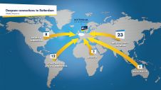
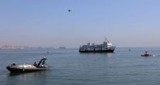
The Port of Rotterdam is Europe’s largest port and is one of the world’s key logistic hubs. Hydrographic data is critical to the Harbour master’s department for the operation of the Port of Rotterdam, to support the nautical accessibility of the deep-sea vessels by electronic nautical chart. The introduction of PortMaps enables the Port of Rotterdam to produce a wide variety of information products, including ENCs, from the Port’s survey data, in less than 48 hours. With over 500 line connections to and from more than 1,000 ports around the globe, the Port of Rotterdam in The Netherlands is the cornerstone of international freight transport. It is the...
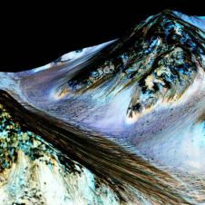
To tie in with NASA’s recent announcement about the discovery of liquid water on Mars, Esri has put together an interactive story map showing the craters and canyons on Mars that...

An extensive Report Card on the US National Spatial Data Infrastructure (NSDI) was published earlier this year by the Coalition of Geospatial Organizations (COGO). One of the seven data themes...
On 9-10 July 2015, at the Portuguese Navy Base of Alfeite (Almada) in Lisbon, 24 Project Partners from 9 countries demonstrated the ICARUS (Integrated Components for Assisted Rescue and Unmanned...

US Hydro 2015 convened at National Harbor, MD, USA from 16–19 March 2015. US Hydro is a biannual conference hosted by the Hydrographic Society of America (THSOA). THSOA and Canadian...
The RIEGL LiDAR 2015 user conference will be held from 5-7 May 2015 in Hong Kong and Thursday 7-8 May in Guangzhou (Canton), China. RIEGL is putting together the agenda...
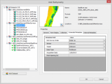
Esri, headquartered in the USA, has released ArcGIS for Maritime: Bathymetry 10.3, adding features such as the support for point feature classes. Some of the added options are: Custom spatial...
This site uses cookies. By continuing to use this website, you agree to our Cookies Policy. Agree