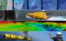
Remote hydrography and regulation: mission impossible?
The development of unmanned and autonomous surface vehicles in recent years has triggered a new era in civilian and military maritime operations. One of the applications that is likely to...

The development of unmanned and autonomous surface vehicles in recent years has triggered a new era in civilian and military maritime operations. One of the applications that is likely to...

Fugro has been chosen by the Florida Department of Environmental Protection (FDEP) to map the Atlantic coastal waters of Florida, stretching from Georgia to Miami. The contract was granted as...
YellowScan, a familiar name in the mapping and land surveying realm, is making a noteworthy entrance in the hydrographic sector with the introduction of its pioneering UAV-based bathymetric Lidar solution....
Proteus FZC has delivered marine habitat maps for four Environmental Impact Assessments (EIA). Proteus completed the mapping components of the EIAs on behalf of oil & gas companies and engineering...
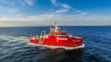
Fugro has finalized an agreement to acquire two platform supply vessels, namely Sea Goldcrest and Sea Gull, to be utilized as geotechnical assets. This strategic move reflects the company’s anticipation...
NOAA and the University of New Hampshire (UNH) recently announced that they are expanding a 24-year ocean and Great Lakes mapping partnership through the creation of a new Center of...

NOAA is sending one of its top fisheries science directors to the Gulf this week to lead its effort to rapidly assess, test and report findings about risks posed to...
Marine GeoSolutions (Pty) Ltd was contracted by the National Research Foundation (NRF) of South Africa to undertake a multibeam bathymetric survey of the northern KwaZulu-Natal submarine canyon system to define...

The South African Council for Geoscience recently launched an initiative to optimize marine geophysical data collection in South African waters. The main aim of the initiative is to produce marine...
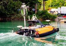
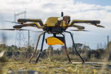
Surveying bodies of water accurately is a challenging task, while authorities and port operators are required to provide up-to-date maps of riverbeds and port facilities. Until now, this has required...
This site uses cookies. By continuing to use this website, you agree to our Cookies Policy. Agree