'Black Smokers' Three Miles Deep
A British scientific expedition has discovered the world's deepest undersea volcanic vents, known as 'black smokers', 3.1 miles (5,000 metres) down in the Cayman Trough in the Caribbean. Using a...

A British scientific expedition has discovered the world's deepest undersea volcanic vents, known as 'black smokers', 3.1 miles (5,000 metres) down in the Cayman Trough in the Caribbean. Using a...

The UK Maritime and Coastguard Agency (MCA) held its annual CHAS (Civil Hydrography Annual Seminar) on 24th February, where many images were shown of wrecks that had previously not been...

SeeByte is to say goodbye to their interns of 2010. The company welcomed three students to undertake six month internships within the company, beginning in June this year. Kyle McNally,...

In about eight years from now business for the United Kingdom Hydrographic Office originating from digital charts will exceed business from paper charts. But according to Mike Robinson, CEO with...

The coastal zone is immensely important for humankind, marine and coastal spatial planning is a vital tool for planning and preserving the world’s coasts. Ron Furness, is a nautical cartographer,...
This is a report on the first IHO sponsored Database Design and Management Training Course delivered to the East Asian Hydrographic Commission. The hydrographic community is tackling some of the...
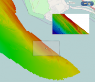
The latest release of Spatial Fusion Enterprise builds on its support of Open Geospatial Consortium (OGC) standards by implementing the Web Coverage Service (WCS) standard for bathymetric data. The new...

During Ocean Business, CARIS officially launched and demoed the new version of Bathy DataBase 3.1 which as a new feature supports Oracle 11g. Delegates interested to see the new development...

Vancouver, Canada will provide the inspiring backdrop to the 14th International CARIS User Conference taking place from 25th to 28th June 2012. Canada's proclaimed "Gateway to the Pacific" famously hosted...
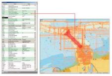
The Flemish Hydrography, part of the Flemish government in Belgium, is currently setting up and integrating a Marine Spatial Data Infrastructure (MSDI) for the Belgian coast, the canal Ghent-Terneuzen and...
This site uses cookies. By continuing to use this website, you agree to our Cookies Policy. Agree