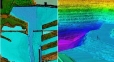
New Airborne Lidar Markets for Optech Titan at ELMF 2014
Optech is introducing the Optech Titan multispectral lidar sensor to the survey and mapping industries at the European Lidar Mapping Forum in Amsterdam, to be held from 8-10 December 2014....
Optech is introducing the Optech Titan multispectral lidar sensor to the survey and mapping industries at the European Lidar Mapping Forum in Amsterdam, to be held from 8-10 December 2014....
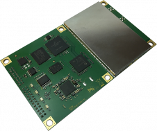
Today, Hemisphere GNSS has announced the Eclipse P328 in a line of low-power, high-precision, positioning OEM boards. The multi-frequency, multi-GNSS P328 is an all-signals receiver board that includes Hemisphere’s new...
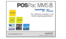
Applanix has introduced POSPac MMS 8 GNSS-aided inertial post-processing software for georeferencing data collected from cameras, Lidars, multibeam sonar and other sensors on mobile platforms. The announcement was made on...
During Intergeo, NovAtel introduced its RTK ASSIST service, a subscription-based service that provides users with satellite-delivered correction data to seamlessly continue centimetre-level accuracy during Real Time Kinematic (RTK) correction outages...
RIEGL traditionally uses the Intergeo platform to give an insight into and an overview of its comprehensive Lidar sensors and systems product range. At booth C3.059 in hall A3, on...
Applanix has introduced its POSPac Cloud software for directly georeferencing data collected from cameras, Lidar, multibeam sonar and other sensors on mobile platforms. As an online version of Applanix’ GNSS-aided...

To gain real insight into today’s hydrographic business landscape, Hydro International asked some of the sector’s most influential companies for their opinions. This series of Q&As focuses on the current state...
Applanix presents in its booth (C1-1537) Position and Orientation Systems (POS) for airborne, land, and marine surveying. Applanix will also introduce visitors to the latest POSTrack Flight Management System technology...

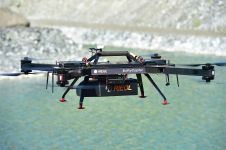
On the first day of Intergeo, RIEGL, Austria, showcased its latest development in UAS-based laser scanning: the RIEGL BathyCopter. This is a small-UAV-based surveying system capable of measuring through the...
This site uses cookies. By continuing to use this website, you agree to our Cookies Policy. Agree