Japan launches project to map 90% of coastal waters
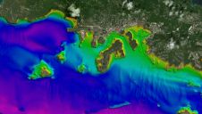
The ‘Umi-no-Chizu’ (‘Map of the Sea’) project will use aerial measurement to map 90% of Japan’s shallow coastal waters (to a depth of 20m). This is a joint project by...
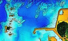
The ‘Umi-no-Chizu’ (‘Map of the Sea’) project will use aerial measurement to map 90% of Japan’s shallow coastal waters (to a depth of 20m). This is a joint project by...
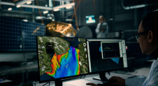
Terradepth has launched Absolute Ocean (AO), a cloud-based geospatial solution providing high-level visualization, analysis, collaboration and management of all marine data. In addition to offering Absolute Ocean as a software-as-a-service...

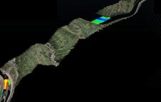
R-evolution has been awarded a contract to supply multidimensional intelligent mapping services of The Bahamas’ seabed. The services are part of a larger initiative to enable the island nation to...

Woolpert sports an innovative and agile team of certified hydrographers, professional land surveyors and GIS professionals. This industry-leading crew develops and integrates topographic, bathymetric and hydrographic technologies to provide clients...
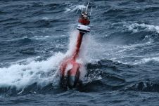
In the summers of 2021 and 2022, an iXblue DriX USV was deployed to try and locate the missing wreck of the sunken French fishing trawler Ravenel. The vessel disappeared...
Topodrone, a Swiss-based designer and manufacturer of high-precision Lidar equipment for installation on drones, vehicles and backpacks, has launched Aquamapper, a UAV-based solution for bathymetric surveying and marine construction. The...
Hydrographers are increasingly aware of the added value that a Lidar (Light Detection and Ranging) scanner can bring to bathymetry survey operations. The Teledyne Optech Polaris Laser Scanner, for example,...

Italo Oliveira Ferreira is a professor in Geomatic Engineering at the Federal University of Viçosa (UFV). He is a geomatic engineer with a Master’s and Doctorate in Spatial Information (Geodesy...
Since the 1970s, remote sensing has increasingly been used to conduct underwater surveys. Several methodologies are employed in hydrographic surveying, from direct techniques such as probing rods to more sophisticated...
We asked five experts for their views on the trends and developments in bathymetric data, as this is and will continue to be the backbone of hydrographic surveying with echosounders,...
This site uses cookies. By continuing to use this website, you agree to our Cookies Policy. Agree